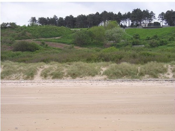
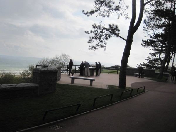
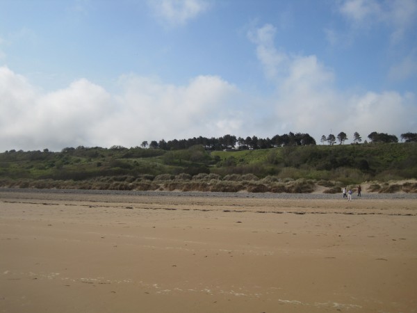
As you stand on the Platform
looking out to sea, this is the view to
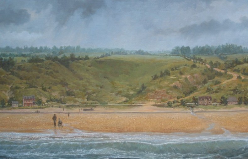
the left of the Platform (due west). That is Omaha Beach below.
If you get in a boat and sail straight ahead, that is due north. England is 100 miles away.
|

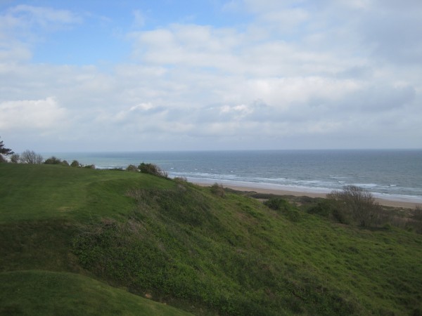
This is the view to the east of
the Platform.
You can see the steps that begin one side of the
double-curved walkway below, i.e. the white semi-circle.
|
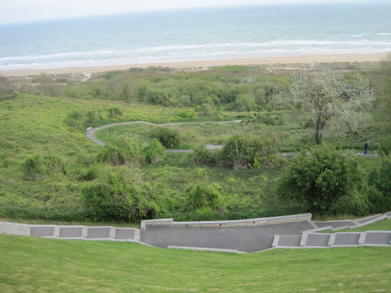
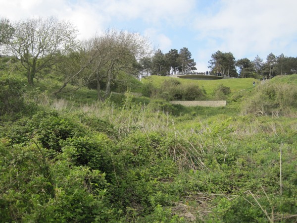
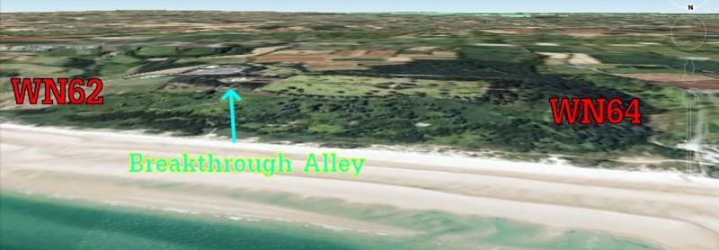
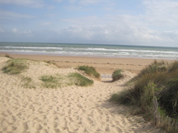
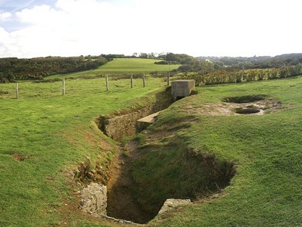
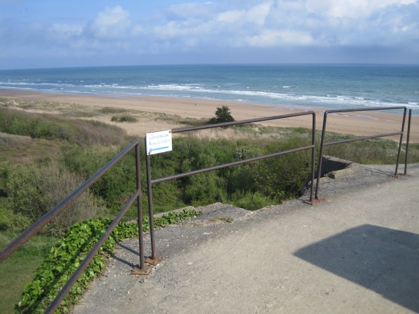
Breakthrough Alley
|
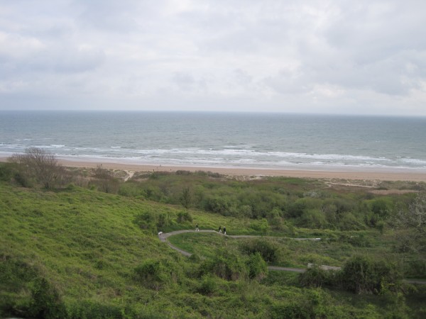
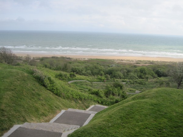
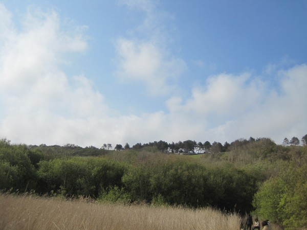
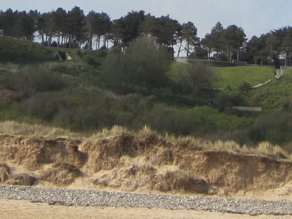
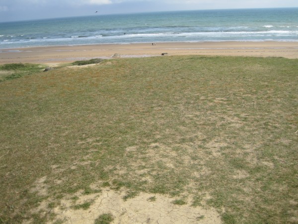
This is the view
directly in front of the Platform.
You are facing north. That little dot on the beach is a man
walking 700 yards away. England is 100 miles away directly in
front of you.
Mine fields and
barbed wire were placed in a marsh area at the bottom of the hill.
Deadly machine gun nests were placed 100 yards from the
shore. In addition, there were artillery and machine gun nests mounted
on either side of the Viewing Platform at the top.As you can see, this
area is beautiful. I don't know if any German or American
ghosts still linger here, but today it is definitely a quiet,
peaceful place.
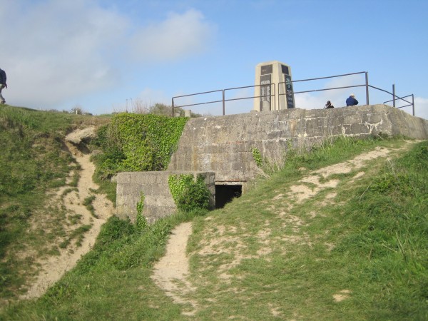
The Platform
had a very commanding view. The slope on either side of the
Platform is much steeper, creating a bowl of sorts. If you are
standing on the beach, the easiest route to the top of the hill is
what you see in this picture.
By the way, there is a
big secret about
the Platform Viewing area that no one told me about during my visit.
This spot is where the amazing Breakthrough occurred to turn the tide.
|
 |
|
|
|
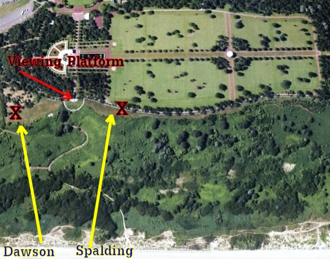
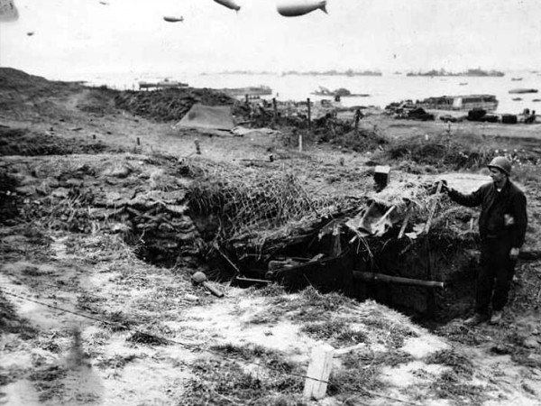
On D-Day, Lt John Spalding's men passed right by
this spot on their amazing breakthrough assault. They faced a
machine gunner in a foxhole stationed at the "X" atop the hill
on the right.
At the same time
Capt Joe Dawson came up the gully and attacked a machine
gun nest 100 yards to the east (see "X"). I will share their
complete stories shortly.
Not one picture I saw of the bluffs on D-Day showed a
tree. Today this area is very lush. I am sure the Germans kept the
underbrush cut back on a regular basis. Think what you may
about Hitler, but give the Germans their due... they were brave in their own right
and they were quite efficient
in the art of war.
This picture does not
reveal that the area on either side of the Platform is much steeper. The steep slopes on either side of
the Platform created a gully that funneled men like Dawson
and Spalding to this spot all day long.
On the day of my visit,
I was told by a guide that many men died fighting for control of the
spot where the Platform is located.
Consequently at the time I assumed I was
standing on a German strongpoint that killed many men in their
attempts to knock it out.
|
 |
I was completely fooled
by the guide's suggestion.
It turned out he was completely wrong.
This gully was
actually one of the most poorly defended spots on Omaha Beach!
Only a few men died fighting near the Platform
and almost all of them were German. The casualties the guide had referred to
were all down on the beach.
I never knew it at the time, but the Platform I was standing on
marked the exact spot that turned the entire day around.
And the gully right in
front of my eyes was the path they took to the top. So I named
it "Breakthrough Alley".
|
|
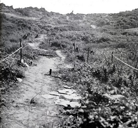
Take a look at
Breakthrough Alley. This picture shows the
same spot as the D-Day picture on the right.
So why was this area relatively undefended? What
I did not realize is that the Germans did not have the manpower to
put strong points everywhere. They had to pick their spots.
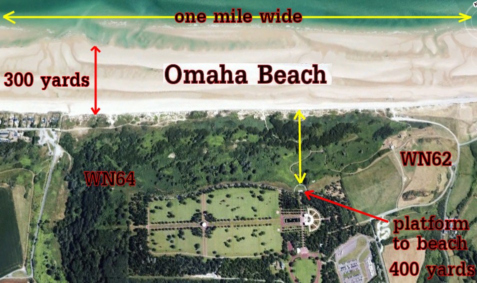
The Platform overlooks a spot
HALFWAY between the WN62
and WN64
Resistance Nests.
Those strong points were located 500 yards to the left and 500 yards
to the right
of the Platform. This middle point turned out to be a poorly
defended weak spot that the Allies were able to exploit.
|
This is a picture of the
trail that Spalding's men took on their way to the top.
Today's Platform is situated right at the top of the bluff.
I had assumed there were once massive fortifications atop the hill.
I later discovered I was wrong. The records only mentioned two
machine gun nests. Spalding took out one on the right and
Dawson took out one on the left. I don't think anything was in
the mid-point where the Platform is today.
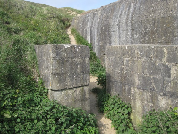
By the way, there was a mine field on either side of the trail. That
explains why someone put the warning ropes on the side.
|
|
|
|
Here's
another look at Breakthrough Alley.
If you were
a German marksman, this would be the vista you would watch all
day long. If that brush was cut back, there weren't many blind
spots for soldiers to hide.
Actually there is one blind spot, but you can't see it
from this angle. The blind spot is the sea wall. Right where the
sand meets the foliage, there is a 4-10 foot high sea wall (also
called the shingle) that offered valuable protection.
|
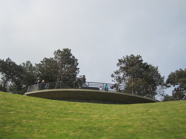
Here is a
look at the Viewing Platform. On the day of my visit, I
overheard a tour guide from another group explain why the Cemetery was placed
nearby. Thanks to WN62
and the prolific Butcher of Omaha, more than half the men who died at Omaha died on the beach
directly below
this Platform. This area saw the fiercest fighting on
D-Day, so this is where the initial Cemetery was created. In other
words, they put it up here because this is where most of the bodies were
located. This area is now referred to as "Cemetery Hill" by
the locals.
|
Here is
another look at Breakthrough Alley. Notice how steep it
is in this area. It is nowhere near as steep down below. Let's take
a walk down to the water and get familiar with the slope. In this
picture, I have just left the Viewing Platform. The walk from
the Platform to the beach is about 400 yards.
Now I have a job for you to
do. Pretend you are a German sniper. Can you see
anything directly just over the ridge on the right? No, of
course not. There is a blind spot here that Joe Dawson used to
sneak up on a machine gun nest nearby.
|
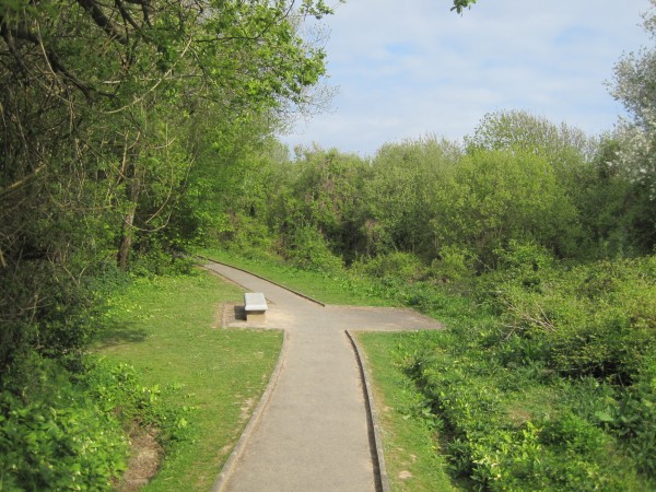
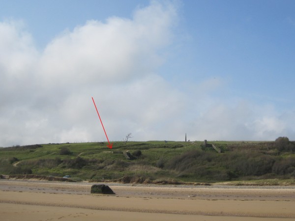
Picture #1
was taken 20 yards below the Viewing Platform. Imagine you are an American
climbing the bluff. Joe Dawson, the man who took out a machine gun
nest with two grenades, was right underneath this ridge to the
left of this picture.
He couldn't see the machine gun nest and the Germans could not see
him either. Dawson stayed invisible as long as he could while he
snuck sideways to get closer. Dawson got to a point that even
with the guns. The moment the nest came into view, he lobbed
his grenades from 30 feet away. Breakthrough.
|
This is
Picture #2. I have descended about 100 yards. This picture
begins to convey that "Bowl Effect" I tried to explain.
The
terrain funneled everyone straight towards the Platform area.
This is an important area, though I didn't know it when I took the
picture. On the hill looking right, Spalding and Streczyk took
out a machine gun nest. On the hill to the left, Dawson took
out a different machine gun nest. You are
looking at one of the most important spots in US Military History.
This is where the first Breakthrough at Omaha Beach took place.
|
This is
Picture #3. I have descended about 300 yards.
That's a long way
to the top. I imagine it is an even longer climb with bullets flying at you the entire time.
It must have
taken a lot of courage to advance. I am sure much of Dawson's
trip to the top was done on his stomach.
|
This is
Picture #4. I am just about to reach the marsh area that
connects the hillside to the beach. This is a protected area. No one
is allowed to leave the trail. As a result, the vegetation
flourishes. I can't imagine the Germans permitted the foliage to be
anywhere near as dense as this on D-Day.
|
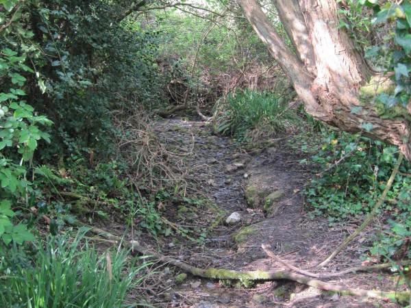
Here is a
little stream that emptied into the marsh area. This picture
was taken just a few feet from the bench in Picture #4.
|
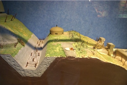
This picture is a model of
the beach defenses created by the Germans on D-Day. They put
pillboxes and machine gun nests close to the beach. These
pillboxes were guarded by barbed wire and mine fields.
The heavy
artillery such as the cannons and mortars were placed further up the
hill. To protect the big stationary guns, the Germans dug a
ditch that no tank could cross.
At first I
assumed the ditch prevented an American tank
from getting get close enough to the concrete bunkers that housed the guns
to take them out. I later learned the ditch was dug to prevent
the tanks from driving up the hill and through to the countryside in case the
WN
strongpoint guarding the pass fell.
That's the
whole reason that visiting the area was so important to me. I
cleared up one misconception after another this way.
|
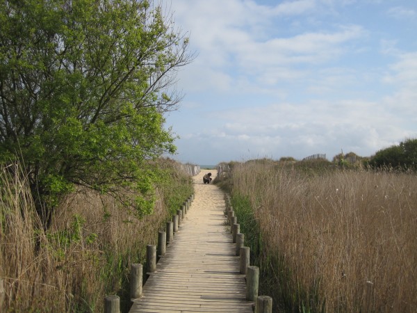
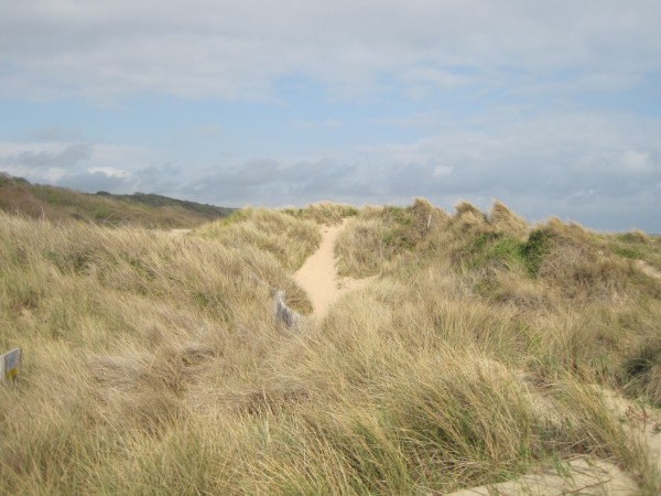
This is
Picture #5. I am now in the marsh area. The sand
up ahead
indicates the beach is nearby.
This area once contained the mine
fields and the barbed wire. I noticed the ground was a bit
soggy in places which explains the need for the wooden bridge.
The
bridge also helps to preserve the landscape. Then it dawned on
me it might also
prevent me from walking on an undiscovered ancient landmine.
Interesting thought. I stayed on the bridge.
|
This is
Picture #6. Here is another look at the lush marshy area. The
beach is 5 feet behind me. This spot is about 400 yards from the Viewing Platform
above. This spot is about where Spalding and Dawson's men began their climb
up Breakthrough Alley about 15
minutes apart. Spalding's men stayed to the right side of this
picture, Dawson's men climbed about 100 yards to the left.
|
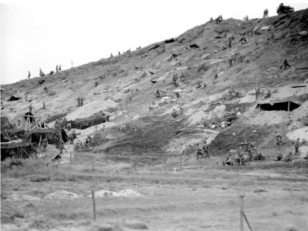
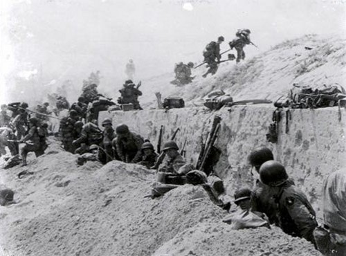
I found a
D-Day picture of the surrounding area that gives a realistic view of the hillside.
Not only does it show how steep the
hills
were, it shows how much the brush was cut back. Not a tree in sight for cover. Not
even a bush!
Imagine crawling up that hill with a machine gun
firing at you. I shudder to even think about it.
|
This marsh
area was very pretty. I can't begin to describe just how
beautiful this entire area is from the Platform on the bluffs above
down to
shore.
Thank goodness we have these pictures to demonstrate
just how lovely the Normandy Memorial is today.
|
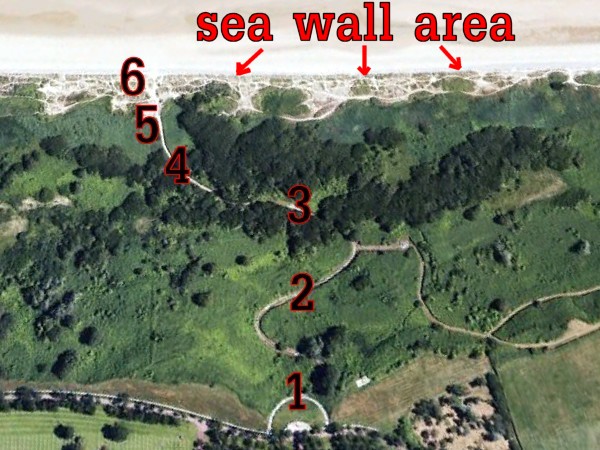
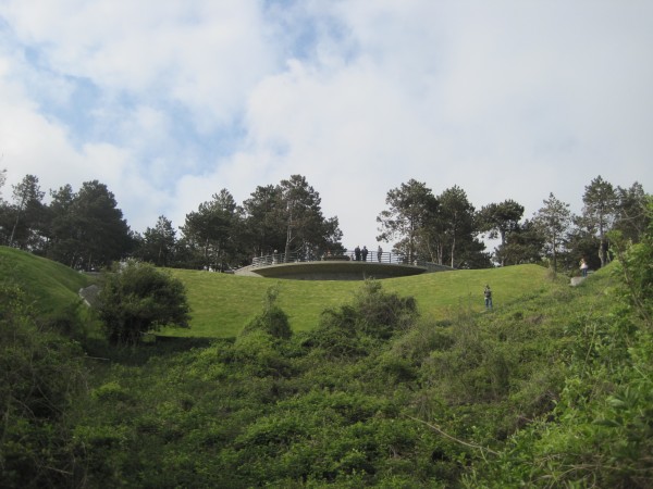
Here we
have an overview of Breakthrough Alley as well as an idea where my
six numbered pictures were taken from.
Using a
ruler on Google Earth, I estimate that this gully was about 400
yards wide at the bottom and 200 wide at the top.
I believe Spalding started
about where that "6" is in this picture while Dawson's men began
further to the right. The terrain formed the letter "V" which
funneled both platoons towards the center, i.e. the platform area at
the top.
|
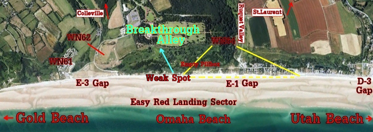
As I wrote earlier, Rommel's biggest fear was letting
American tanks get through into the French countryside.
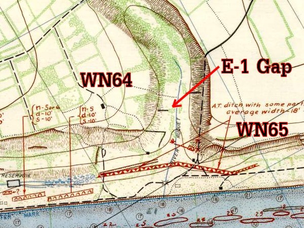
This 3-D overview shows "Cemetery Hill" with a narrow gap on
the right (west) known as Ruquet Valley.
This was the "St.
Laurent Draw". It was defended by
WN 64.
There was a wider gap on the left. The "Colleville
Draw" was defended by
WN 62.
|
 |
The
WN
strong points overlooking the Draws (a military term
for the gaps between the hills that led to the countryside) did indeed prevent any
tank breakout till late in the day. However, the
defenses between the strong points were weak at the
Easy Red sector. This soft spot allowed the infantry penetration
at 'Breakthrough Alley' that turned the tide for the
Americans.
|
|
|
|
|
|
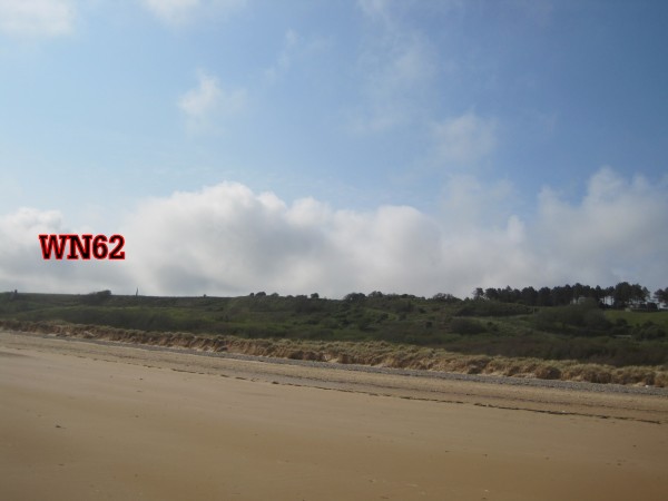
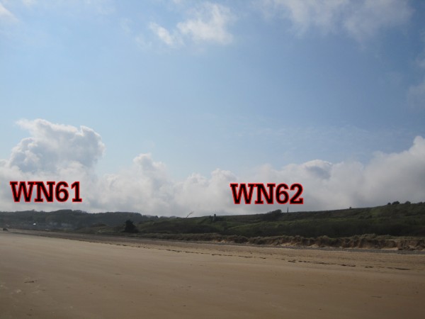
This is a
picture of the terrain to the EAST of the Platform.
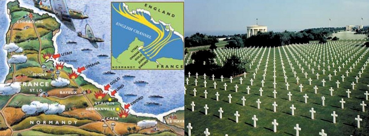
Twelve miles to the left from where I stood facing the Platform was
Gold Beach. That flat area to the left is the valley defended by
WN62, the
deadliest spot on D-Day.
|
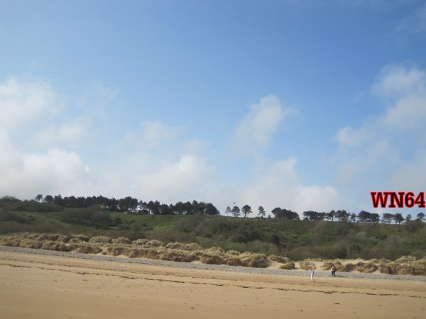
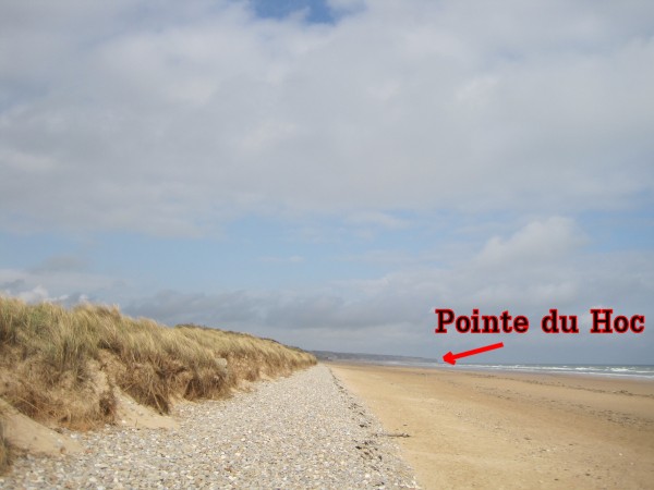
This is a picture of the
terrain to the WEST of the Platform.
Fourteen miles to the right of where I stood to take this picture was
Utah Beach.
Seven miles to my right is the famous Pointe du Hoc, scene of some of
the most intense fighting on D-Day.
|
I haven't said much about
WN64. To
say a strong point is a weak link is something of an oxymoron, but that
was the situation.
WN64 was
positioned to dominate the entrance to the Ruquet Valley at the
E-1 Gap.
WN64 was designed to protect an area nearly 3/4ths of a mile long.
The area in the yellow triangle in the picture above marks the range
of its guns. I assume artillery could go further.
This strongpoint was largely uncompleted by D-day. Unlike its
neighbor WN 62
1,200 yards away, not all the guns had been installed yet.
Furthermore, its most powerful guns were trained on the valley of
the E-1 Gap. That left a weak spot midway between the strong points
where defensive responsibility was transferred to smaller gun units like
pillboxes and foxhole machine guns.
Breakthrough Alley (light
blue line) was fortunate that neither strong point could see into
the ravine once the men were able to get off the beach. Both strong
points could see all along the beach, but neither strong point could see
Breakthrough Alley because it was hidden in a low gully. Yes, there were still individual machine gun
nests, mine fields, and pillboxes to contend with in Breakthrough Alley, but nothing remotely as powerful on the scale of the fearsome
WN62.
WN62 had
an unobstructed firing line along the beach that allowed it to kill
a thousand Americans, but was unable to see Dawson and Spalding's incursions into Breakthrough Alley.
This
picture does a good job of showing how narrow the E-1 Gap is.
The narrowness made the St Laurent Draw easier to defend. Now compare it to the
wide-open E-3 Gap. That valley was 600 yards wide. Pop a few tanks through the Colleville
Draw fast
enough and they wouldn't stop till they reached Paris 150 miles
away. Now you understand why the E-3 Colleville Draw was assigned so much
importance.... which is also why Rommel defended it so well with
WN62....
which in turn led to the loss of so many American lives.
The
American military planners were convinced the 600 yard wide E-3 Colleville
Draw gave
them their best chance of breaking out. So they attacked the
teeth of the defense so to speak. They threw the most men into
attacking this spot... and got most of them killed in the process...
which is why we now have Cemetery Hill nearby.
WN62
was clearly the strongest part of the German defense. Ironically,
less than a mile to the west of WN62
stood WN64, the weakest part of the German defense. As
they say, you are only as strong as your weakest link. Rommel
failed to beef up
WN64
because the St. Laurent/Ruquet Valley Draw was so easily defended.
Almost all of WN64's
most powerful guns were aimed towards Ruquet Valley.
Anyone
lucky enough to land in the mid-way weak spot actually had a
fighting chance to reach the sea wall alive because the bullet
saturation was so thin. In fact, perhaps the bombing did take
out at least one defensive unit. A soldier named Clarence Colson asserted that a
pillbox built to the defend the mid-point
at Breakthrough Alley was not in action during the attack.
Colson
stated, "Of
course
they were firing, but there was one pillbox way over and there was
nothing coming from that."
I read nothing else on the
Internet to
corroborate this, but assuming Colson's statement was correct, the weak spot
became that much weaker.
From the weak spot
landing point, the most direct route
from the weak spot up the hill funneled the assault teams directly through
Breakthrough Alley towards the Viewing Platform high above on Cemetery
Hill.
Strongpoint
WN64 was
the first German resistance stronghold to fall. It was cleared
by Spalding's men around 1000 hours (10 am)
on D-Day, although a lone pillbox
at the head of the draw remained in German control until the
evening.
The powerful
WN62
strongpoint
managed to hold out till 1500 (3 pm). As it turns out,
Breakthrough Alley allowed the soldiers a safe way to the top
despite the continued presence of
WN62
nearby. Some of the soldiers who climbed to the top of
Cemetery Hill using Breakthrough Alley assaulted WN62
from behind, leading to its eventual fall.
It is clear that the courageous work of Dawson's Company G and Spalding's
Company
E to create the Breakthrough Alley breach saved an immeasurable
number of lives.
|
|
This spot
was probably exactly where Spalding's platoon first cleared the barbed
wire to begin their climb to the top.
Can you imagine a battle being fought in a place this pretty?
There is nothing
around this area that even remotely suggests the horror of June 6, 1944.
|
These rocks are known as the
"Shingle Shelf".
There were reports of a deep
anti-tank ditch on the beach. I had heard that it was 18
inches wide and was flooded. I kept wondering how 18 inches
would stop a tank. Curious, I spent all morning looking for
traces of the ditch, but saw nothing to suggest its presence.
This was one of my mysteries of the day. Finally I gave up and
assumed the ditch was filled in.
|
When I
began to write my story one year after my visit to Omaha, I saw a
picture of the anti-tank ditch in front of this
WN62
casemate.
So there was a ditch after all! Where did it go?
|
Then out of
nowhere my mystery was solved. As I scrounged around for
information on the Internet, I found this map of the E-1 Gap
defense. Sure enough, there was a caption that said Anti
Tank ditch, average width 18 feet. I laughed. 18
feet made a lot more sense than 18 inches! Then I realized the
ditches were placed in front of the Gaps, not the hills.
Ah!
Now I get it. The ditches were in front of the draws. Why put a ditch in front of a
hill?
Let the steep hill stop the tank.
|
Another
mystery of the day was trying to locate the sea wall. When I
reached the beach, I looked everywhere for the concrete sea wall
seen in this D-Day picture. It was nowhere to be found. At
first I assumed someone must have removed the concrete sea wall
when they landscaped the Normandy Memorial, but I didn't like that
explanation. That would have been a lot of work with not much
reason. So I took another look at my own pictures.
|
That rocky
area is known as the "Shingle". A shingle is beach gravel consisting
of large smooth pebbles unmixed with finer material. That rock
shingle is what helped create those large sand dunes behind it.
|
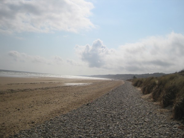
That is
when I noticed how high those sand dunes were. Hmm. The
reports said the men rested at the Shingle. Hmm. Now
that I think of it, doesn't this picture look like a sea wall to
you? Those dunes would offered a lot of protection from bullets
flying down from above.
|
I decided
that in this particular area of Omaha Beach, this must be the sea wall the
reports referred to. Some places had a concrete wall, but here
the protection was a "natural sea wall".
This shingle area had to be where the dazed assault soldiers huddled
for safety. I can definitely see how the men would have been safe
for a while if they reached that spot.
|
This is
Picture 7. At this point, I began to walk the beach to my left. I
was headed east towards Gold Beach. I noticed there was a
bunker where the red arrow is pointing, so I walked over to check it
out. I did not know it at the time, but I had inadvertently
stumbled on the killing ground of
WN62
|
I was
walking straight towards the machine gun nest manned by Heinrich
Severloh, the Beast of Omaha Beach. He sees me and shoots.
Boom. I'm dead. Killed in the line of fire. How
many widows and parents received that message on D-Day? 2,000.
|
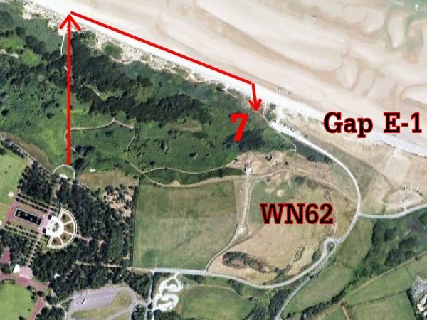
From above,
we can keep track of my path. I was headed straight to the
middle of that wide field. This picture gives an idea of just
how open this "Gap" was. No wonder this 600 yard
opening was so tempting
to the Americans.
|
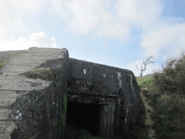
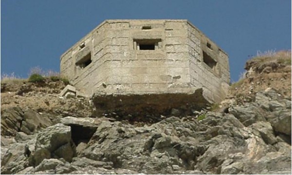
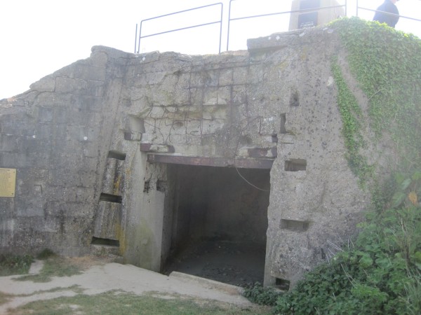
I noticed
two very large casemates (bunkers) still standing. These
remnants of
WN62
had incredibly thick walls.
|
When I went
inside, I could see this bunker was virtually intact. And it
was standing in plain sight in the middle of a field! This
indicates how ineffective the bombing campaign was.
|
Notice
how thick the concrete was. I came to one very obvious conclusion -
these bunkers were definitely built to withstand heavy bombing. I
began to wonder if this bunker had been hit at all. I barely
saw a scratch on it.
Maybe I didn't see any bunkers that did get hit because they were
reduced to rubble. That makes sense.
|
This bunker
was perhaps a hundred yards from the beach. It was in perfect
position to fire mortars. Look at how close it was to the
beach! And look at those sight lines. This was the
area manned by Heinrich Severloh, the Butcher of Omaha.
There was no sea wall here. No wonder the men in
their landing boats were such easy pickings.
|
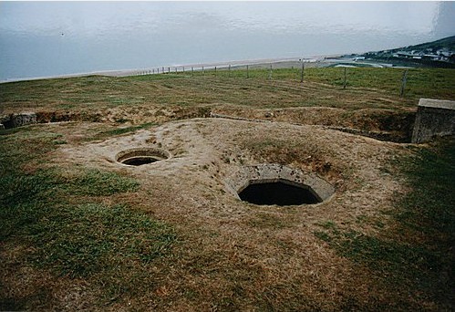
Here is the
second WN62 bunker. Call it
Picture 8. It was about
50 yards further up the hill. Like the other bunker, it was
completely intact as well. I marveled how the bunker was built
right into the hillside for further protection. Most bombs
from a ship would have flown right over it or struck the side of the
hill harmlessly. It would have taken a direct hit from an
airplane bomb to take it out before the battle. Not likely.
|
Do you see any signs of damage?
Me neither.
|
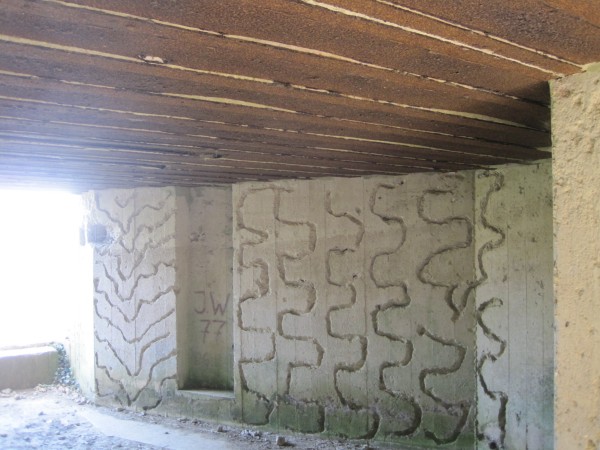
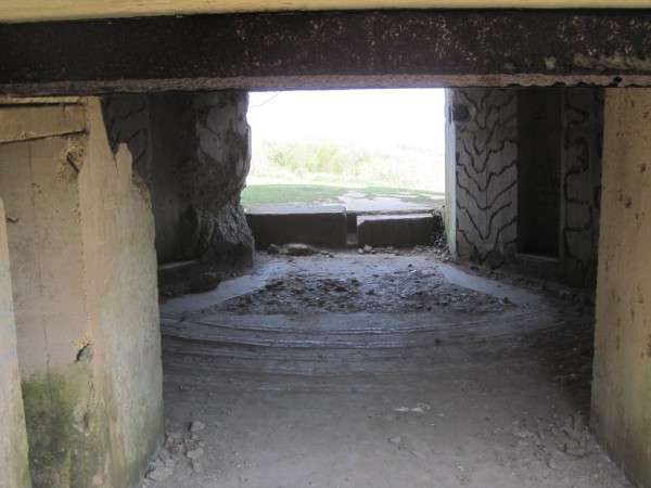
The ceiling was reinforced with
steel. |
This bunker was part of Strongpoint
WN62
|
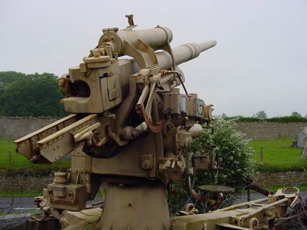
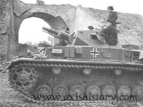
This 75 mm anti-tank artillery
gun was the kind of weapon
housed at these bunkers.
|
These
trenches allowed the men to ferry ammunition to the front and to
travel from one bunker to another without danger. That small
foxhole on the right was said to be the exact spot where Heinrich
Severloh manned his death-dealing machine gun.
His gun
could be reloaded using a tunnel for protection.
|
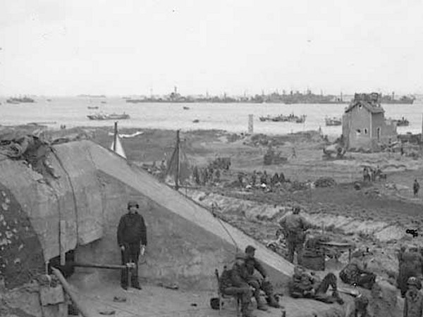
This is a
picture of
WN62
taken on D-Day shortly after the strongpoint fell.
|
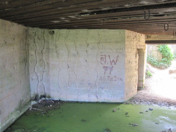
An
impromptu sign commemorating the 77th Panzer Division. It is
my understanding that many Germans come to visit this site.
I am sure they are just as curious about their past as I am about my
own. During my Internet research, I came across many books
about Omaha written by German authors. They had titles like
"The Murderous Elite of the Atlantik Wall", "The Hillside Bastion" and "WN 62 -
The Stronghold that Defended Berlin". The Germans
have a lot of pride about this spot.
|
I think my
politics are fairly obvious - the Americans were the good guys, the
Germans were the bad guys. Nevertheless, I couldn't help but
develop a respect for the German soldiers. Most of them
were just taking orders and doing their jobs... very effectively, I
am sorry to add.
I am not
sure I would be quite as forgiving if I lost a child or a buddy in
this battle.... or lost a leg of my own for that matter.
|
|
|
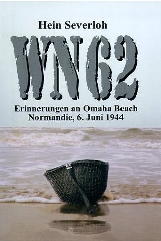
This book was a huge best seller in
Germany
|
Someone calculated that approximately
900-1,200 Americans were
killed or wounded in front of
strong point
WN62.
Of the men that died, Heinrich Severloh was responsible
for most of those deaths.
He was the designated shooter.
The other men spent their time using to the trenches to
bring more ammunition to reload his gun.
I was curious to know more about Heinrich
Severloh, nicknamed the "Beast of Omaha".
Severloh told his story in "Memories
of Omaha Beach". I
discovered Severloh was a simple
country boy who found himself in the middle of one of
the world's most climactic events.
I had expected a proud and defiant look at the events
of the day, but was surprised to see this book was an
apology of sorts. Severloh's
book did not read like a killer who brags about his
exploits, but rather that of a reluctant soldier
and an even more reluctant killer.
Severloh took no initiative on that day, but rather simply
followed orders. He was told to man a particular
gunnery spot and not leave under any circumstances.
The book relayed his heartfelt words describing the
horrible events on that beach.
Severloh
said he deeply regrets his role in those events
and would carry an unshakeable guilt to his grave.
Severloh revisited his painful
memories of cutting down a
thousand U.S. soldiers with his MG-42 at the Easy Red sector
with vivid and gory detail. The
author stated his belief that his
machine gun position inflicted the most damage and killed
more U.S. servicemen than any other during the war. He did
not boast of this deed, but rather told
of his actions with deep regret.
Historians who reviewed the book concluded it is
certain that Severloh did inflict
somewhere around a thousand
American casualties on June 6, 1944 on Omaha Beach.
Half the American casualties took
place trying to dislodge the formidable
WN62
defensive position using a frontal
assault.
Severloh gave a fresh view of the relationship between
the German occupiers of France and their native hosts. Much
has been written in the years since the war of how much the
French hated the Germans, and there were some who
undoubtedly did, but Severloh gives the reader a
different look. He wrote that not all French hated their conquerors.
Many French
rather liked the Germans and were more than
content to live under their rule.
|
Severloh's book also tells the
story of his recent celebrity status.
Just as his career
as a soldier led to guilt, now he
attained an unwanted celebrity status that had at times
hurt him. The scrutiny forced him come
to grips with his memories.
When asked by a BBC reporter to share
some of the thoughts that passed through his mind, Severloh
nervously slapped his thigh in an attempt to fight
back his tears as his mind went back to that day of
slaughter. Severloh wept as
he said: "What should I have done? I
thought I would never get out of there alive. I thought I am
fighting for my life; it's them or me, that's what I
thought."
Severloh confessed he spent the entire
morning mowing down Americans as
far away as 600 yards at Omaha
Beach. "At that distance,
the enemy looked like ants," he said. "That
didn't bother me as much. I was just shooting at a spot
assigned to my station."
At one moment the
fighting became personal. It happened when
the other men were reloading his machine gun.
Severloh
reached for his rifle during a lull in the fighting.
|
This is said to be Severloh's firing position at WN62 |
A young GI who had survived the onslaught in the sea was
running up the beach.
Severloh
saw him and took aim.
He fired a round
that smashed into the GI's forehead
and sent his helmet spinning. The
soldier slumped dead on the sand. Severloh
still remembers the man's contorted expression.
"It was only
then I realized I had been killing people all the time," he
said, "I still dream of that soldier now.
I
feel sick when I think about it."
|
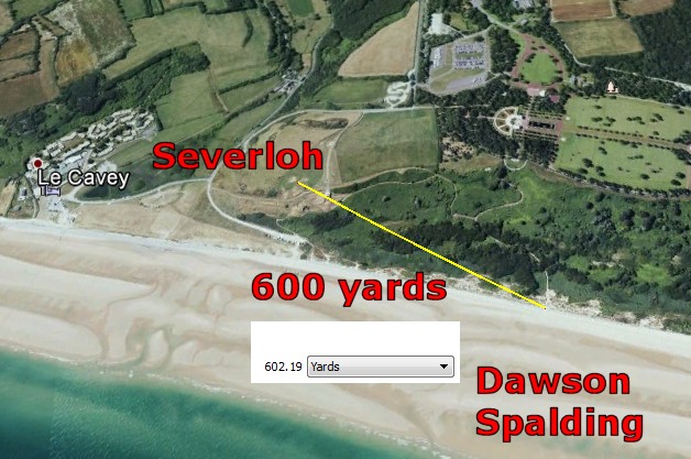
Rick Archer's Footnote: Severloh
said he was able to hit targets as far away as
600 yards. Using Google Earth (a
phenomenal tool!), I measured Severloh's
position to the point where Dawson and Spalding
began their ascent up Breakthrough Alley.
The distance was 600 yards.
Through some miracle, both Dawson and Spalding
landed on the only spot on the beach where
neither the WN62 nor the WN64 stronghold could
hit them.
Their landing point wasn't a blind spot, but it
was safe.
Furthermore, once they were in the ravine, they
were invisible except to the few Germans left to
stop them from climbing the hill.
Dawson, Streczyk and Spalding made sure that
wasn't going to happen...
|
 |
|
|
|
Gazing at
the beautiful ocean, the lovely beach, and the lush foliage
everywhere, it is difficult to comprehend the savagery that took
place here. To a visitor like me, this is the perfect view.
To a German, this is a perfect view with a much different objective.
The perfect lines of fire mowed down hundreds and hundreds of men
who never had a chance... right from this spot.
|
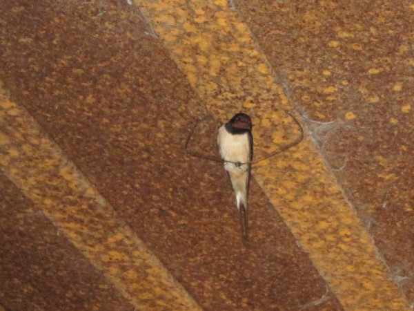
A bird.
Inside the
bunker, life goes on.
As it should.
|
"Stutzpunkt
WN62" is German for "Strong Point
WN62".
WN62 was
unquestionably the most powerful of all the German
WN Resistance
Nests. Thanks in large part to the exploits of men like
Heinrich Severloh, the American Cemetery is located just six hundred
yards
away... a grim testimony to the overwhelmingly efficient killing power of
WN62.
|
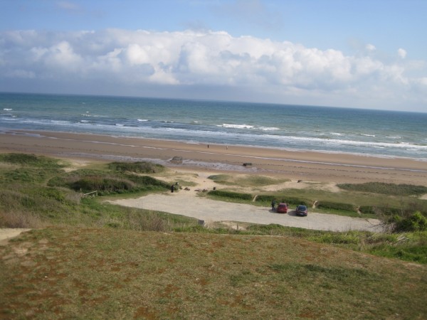
One final
view of Omaha Beach where 2,000 Americans met death on D-Day.
This land has been donated by the French to the Americans "in
perpetuity" for the purposes of maintaining this permanent memorial.
I
guess that makes it American soil in a way. Heaven knows there
is plenty of American blood in that sand.
|
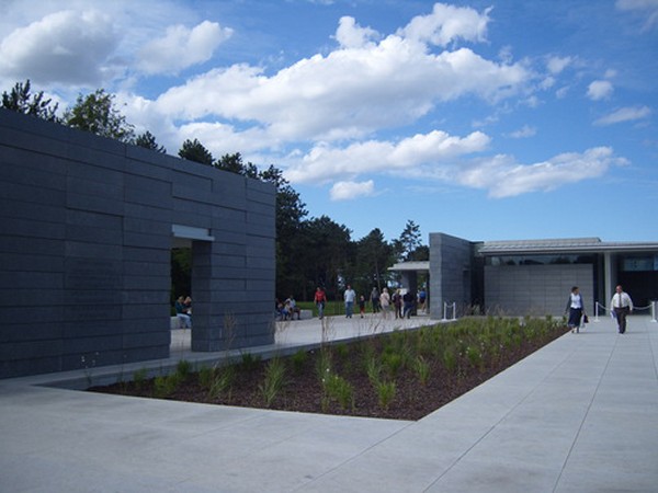
This is
Picture 9, the Normandy American Cemetery and Memorial Visitors
Center. Save plenty of time for this spot. And bring a box of kleenex. I watched a couple videos in there that turned me
into a mud puddle of tears. Powerful place.
|
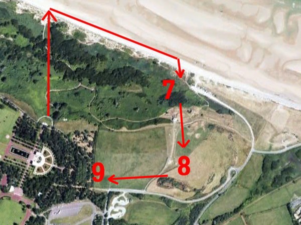
By the time
I reached the Visitors Center, I had made nearly an entire circle.
It was definitely an amazing adventure for me.
90 minutes is NOT enough
time. Spend the whole day there.
|
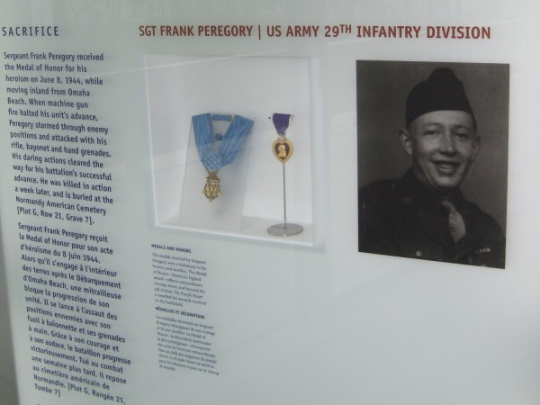
The theme
of Sergeant Peregory's memorial is Sacrifice.
I remember breaking down in tears reading his story. I couldn't bear
the thought that this man had died so that children like myself
could live safely and enjoy so much opportunity in a wonderful
country like the United States.
And what was Peregory's reward? This memorial.
I am fairly positive given the choice everyone of us would choose a
life of comfort. Life is not fair, no question about it.
|
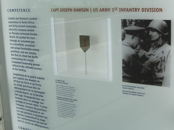
Joe Dawson
is the man most responsible for establishing the first breakthrough on the
bluffs in the Platform area.
After his
service in Normandy, Dawson continued to serve as commander of G
Company through the campaign in France, Belgium and, finally, to
Aachen, Germany. Dawson's G Company held off German counterattacks
for thirty-nine days during the battle for Aachen at a spot that is
still called "Dawson's Ridge" in U.S. Army history.
This ridge sat astride the main route that for the German attempts
to relieve the city of Aachen, which Hitler had ordered to be
defended at all costs. G Company lost 117 out of 139 men during the
battle for "Dawson's Ridge." For this action, Dawson's command was
honored with the Presidential Unit Citation.
In June 1994, Dawson
revisited Normandy to introduce President Bill Clinton during
ceremonies marking the 50th anniversary of the invasion. A
native Texan born in Waco, Dawson lived in Corpus Christi after the
war. A geologist by trade, Dawson and his wife Melba had two
children. What a remarkable man.
|
Rick Archer's Note:
What I
saw at Omaha left me in tears most of the day. I couldn't believe all those men were
sent onto that beach DEFENSELESS.
I was appalled
to see my worst fears confirmed - at the start of the day, the Germans were
able to mow down the men effortlessly. The killing was so easy
that several German gunners later complained they could have killed more Americans if
their arms hadn't begun to hurt from firing so much!
It rankles me no end that these men were sent in without protection.
Why couldn't they give these poor men at least a fighting chance!?
Nothing upsets me more than asking good men to sacrifice their lives in
such a senseless fashion. These were men who had mothers who
went through agony to give birth, then spent countless hours
feeding, bathing, clothing and nurturing these boys... just so some
general could send them off a boat and hope that statistically one
in five would be lucky enough to make it to the sea wall. It
makes me furious.
I would expect more from my
leaders... a lot more. There had to be a better way.
To me, the
major theme of the D-Day classic Saving Private Ryan
was about the intense "survivor's guilt" experienced by the Matt
Damon-"Private Ryan" character. After the war, the Ryan character was determined to
lead a good life. Leading a good life was the only way his
conscience could allow him to accept the noble sacrifice of life by the Tom Hanks character as well as the other men in Hanks'
company who died trying to protect Ryan.
I cannot
imagine how hard it would be to lead a life knowing people that I
knew and cared about had gone to their death so that I could live.
My time at
the Normandy Memorial was tear-filled. I cried on several
different occasions over the pain and the sacrifice on the part of
so many brave men... our "Greatest Generation". They were able
to overcome the incomprehensible fear of dying as well as the fear
of intense suffering so that a death-dealing tyrant like Hitler
could be removed.
I think
anyone reading my story will agree we all owe a huge debt to these
men. How we can ever repay that debt is a difficult question.
I for one
do not have an answer. I suppose the time I spent on this
article retelling the story of D-Day is my way of paying respect.
And now
let's read about the three American heroes, Joe Dawson, Phillip
Streczyk and John Spalding. These were the men who led the penetration that saved the day.
|