|
The
Magnificent
Swiss Alps and its Rivers
|
 |
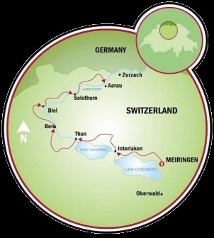
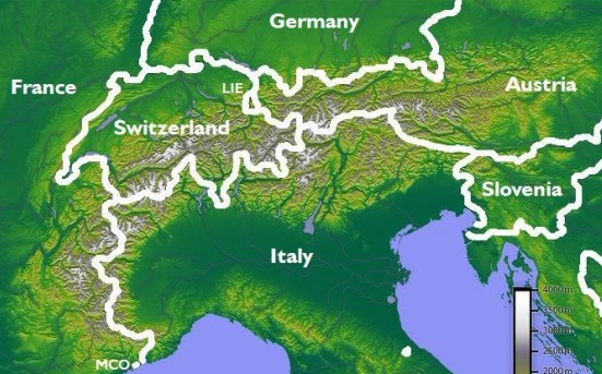
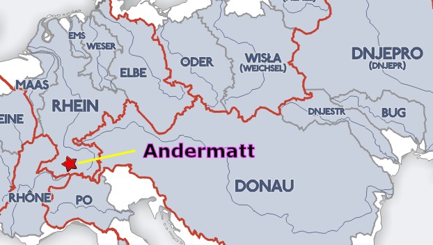
Rhine,
Rh¶ne, Danube, and Italy's Po River
Did you
know the
Four Major Rivers of Central Europe
are
created by
the
Swiss Alps?
|
 |
 |
|
Rick's Note: I remember the
first time I ever saw the Rocky Mountains. I had to
stop my car and stare in awe. Then I started to cry.
I could not believe anything so beautiful as these
magnificent mountains could possibly exist.
I
have to be honest. Now that I have finished this article, I
am convinced the Alps are just as pretty... and maybe
prettier.
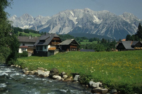
The Swiss are a very clever people. They have bored
all kinds of lengthy tunnels into these mountains which make
crossing this relatively small country fairly easy to do by
car or train.
I
think Marla and I are going to be too busy to make to the
Swiss Alps on this particular trip, but I understand some of
our friends have discussed making forays into the mountains
via the popular train rides. If you end up doing this,
please don't tell me because it might break my heart.
The Swiss are interesting in another way. They have
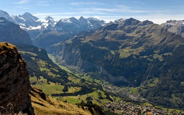
adapted well to their strange environment. Every inch
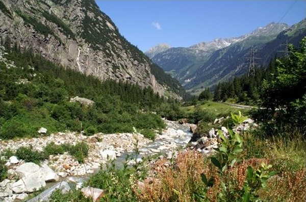
of every valley has four things. It has a river.
It has a road that follows the river. It has farmland
wherever possible and it has one town every mile.
Here's a trivia question for you. Do you see
LIE
and MCO in the picture below? What is the
meaning of those letters?
I
haven't quite figured out the difference between the Swiss
Alps and the Rocky Mountains. Using
Google Earth, my impression is that the Swiss Alps are
tightly clumped together while the Rocky Mountain range is
longer, more spread out, and less green.
I
found a website where Colorado natives who had visited the
Swiss Alps were asked to compare. I enjoyed their answers.
Being
a Colorado native now living in Europe I feel that there
is a great difference between the mountain ranges.
The mountain towns of the Alps have a very different
feel of course and the beauty is very different.
For example there are no Aspen trees - so the color is
much different. The Alps have a much
more rapid increase in elevation but are not as high as
the Rockies.
June
in the Alps is glorious with all of the lush green
mountain meadows full of wildflowers. The Rockies are
more rugged and are really considered high desert, thus
not so lush.
I can only compare the Alps with several skiing resorts
around the Vail area. In my opinion, the valleys
in the Alps are much more narrow and the mountains
appear to be definitely steeper. It's a
completely different kind of vegetation and thus the
color scheme is different.
But
here is what is even more important: In the Alps every
valley has different variations of food, cheese, schnappses, dress, culture... because for centuries
they were cut off from each other. Winter weather
made it impossible to "travel" and in summer you simply
were too busy. So the Alps are all about the people,
customs, foods and sometimes even the style of music
that's important to experience in the Alps.
Just outside Beaver Creek,
Colorado, I found a giant Walmart and
something like a huge Home Depot around a big parking
lot with plenty of other fast food places. Unlikely
you'll find that in the Alps ;-) They treat every
corner of their country as if it is special.
We do the
Canadian Rockies almost every year. They are
beautiful and you can never get tired of them, but I
agree with others, the Alps are amazing.
They
scream "Heidi" at me, the chalets with flower boxes (yes,
really, not just on postcards) the cows in high
meadows, the farmers out on hill sides raking their hay
in by hand (a machine might tumble over on the slope I suppose).
I would
say the Rockies are a bit more rugged. And there
is a wilderness to the Rockies - deer, mountain lion,
bear, and elk, plus so many other animals. Have never
seen wildlife in the Alps.
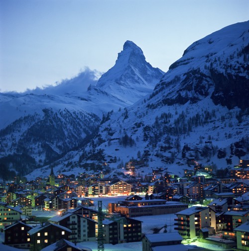
I
liked the hiking we did around Zermatt, so many well
marked trails, and I loved being able to go on my own for a
day hike and not worry about the cougars or bears in
our Rockies!
Based on
the area you hike in Colorado, you don't see a lot of
glaciers...but where we hiked in Switzerland, it's
almost a common sight (although they are melting at an
alarming rate).
The high lakes are amazing in both places, and the snow-capped Rockies, with miles and miles of mountains are
wondrous. In Switzerland, you can hike from town to
town, in the Rockies, that's almost impossible!
Hiking in Switzerland, you come upon little cafes...not
so in Colorado. Hope this helps just a little.
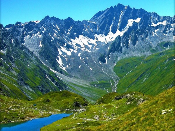
The mountains in Switzerland are much more dramatic. The
higher villages are so amazingly pristine! You can be
hiking and see dramatic snow capped peaks. You get closer
and in
front of the mountain are flower covered meadows with cows
grazing with their cowbells singing! It's magical.
The main difference for me is the loneliness. In
the Rockies you just don't see the human influence over
centuries . On the other hand, the Alps are
teeming with culture and civilization. In the
valleys, there is another town every mile. I can
see why - the Alps are very beautiful and offer a very
laid back style of living.
If I had to pick a place to retire today, it would
probably be somewhere in the Swiss Alps. I love the
Rockies but just a different feeling comes over me when
in the Alps.
If you love the mountains, you must go see
the Alps.
Well, what do you think? Are you ready to give live in
the Alps?
These two recollections indicate that living space is so precious that the
Swiss treasure every single inch. They make conscious
decisions how much of the forest to let stand and how much
to convert to agriculture. This isn't just a Swiss
habit either.
In many parts of Europe, they have so little land that they
take great pride to beautify and protect what they have.
They treat their rivers with reverence. They make sure
their homes and buildings are well maintained. They
have an obsession with clean streets and fresh paint.
They treat forests as a national treasure and they wouldn't
dream of putting up billboards in public areas.
At least that's my impression.
Here in America, we have so much land that it never dawns on
us to maximize its beauty and value. We haven't
developed that attitude that 'America the Beautiful' should be
a way of life.
So, did you guess that
MCO and LIE stand for Monaco and
Liechtenstein? If so, then you should be ready for
my next challenge. How well do you know your
European rivers?
|
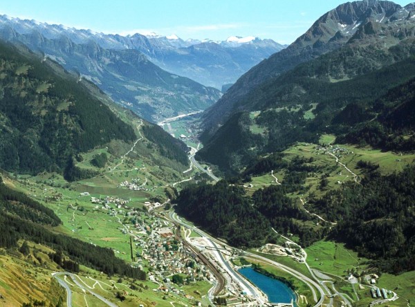
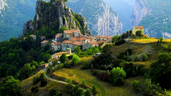
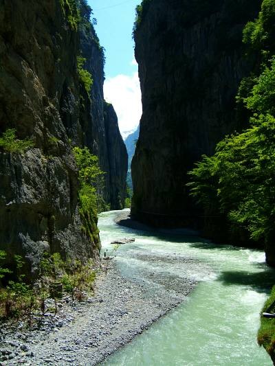
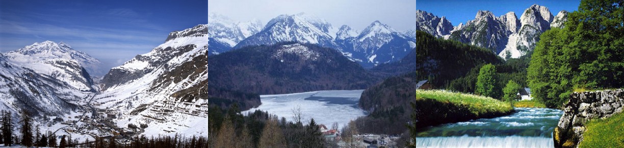
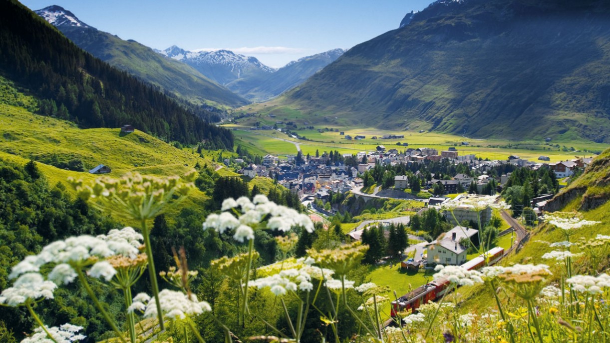
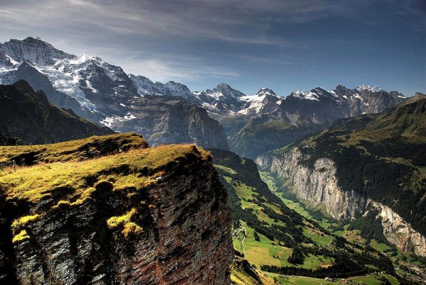
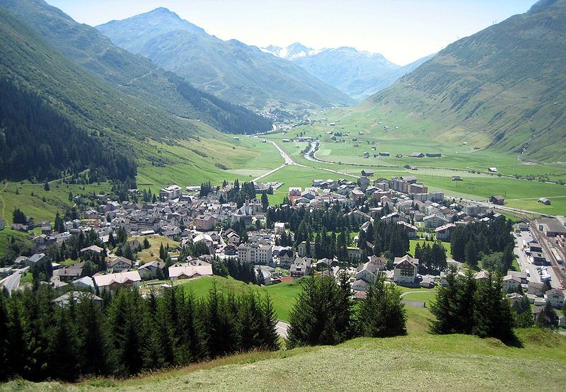
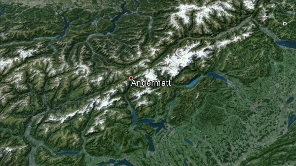
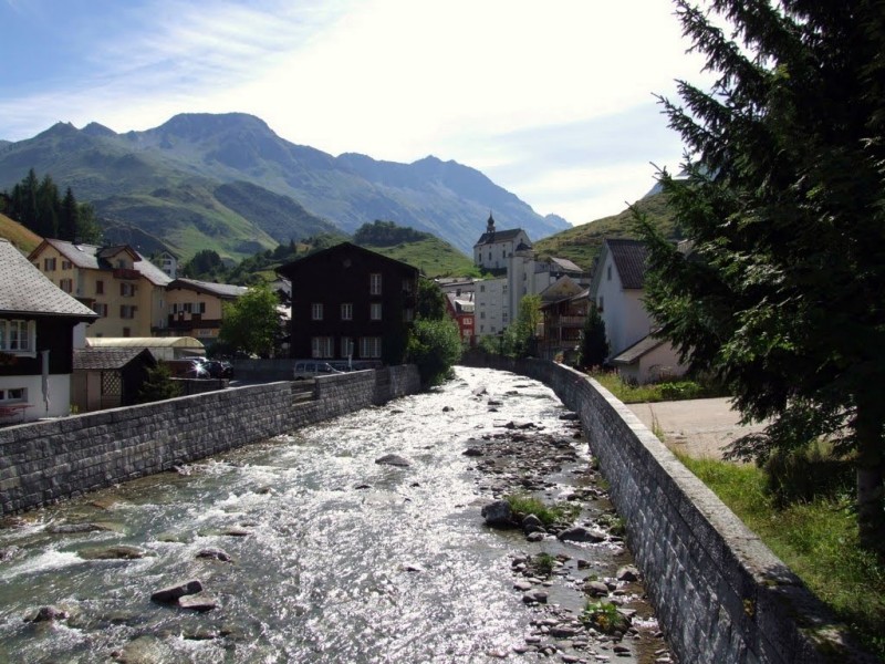
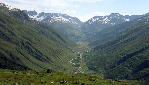
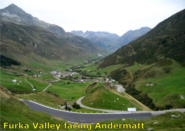
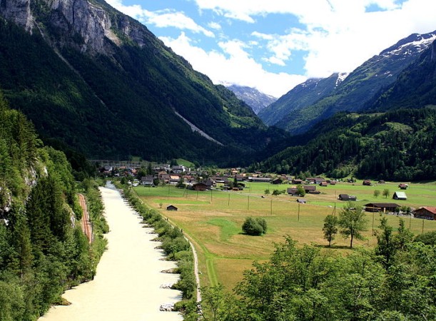
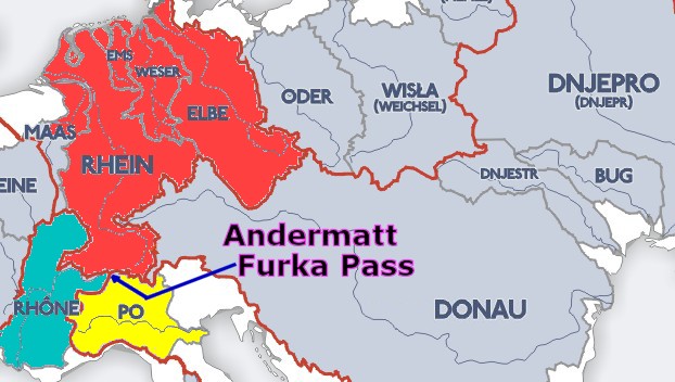
The
picture above and below are both pictures of the area around Andermatt, my
adopted Swiss town. From what I gather, there are
postcard pretty hamlets like Andermatt spread throughout
Switzerland. I
have to say the pictures I found for this story have led me
to conclude that Switzerland fully deserves its reputation as
one of the world's most beautiful countries. What a
treasure.
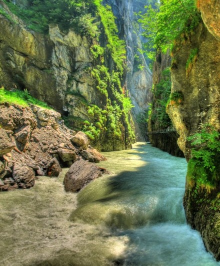
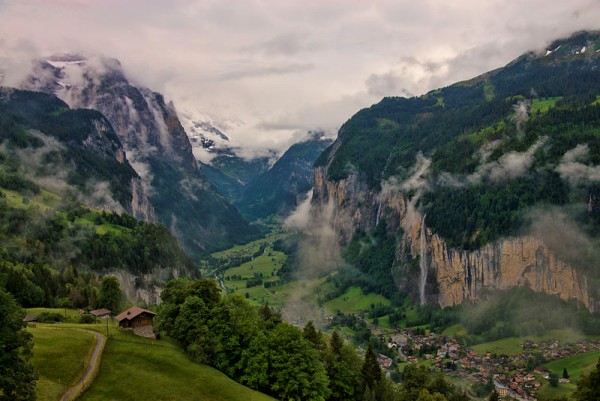
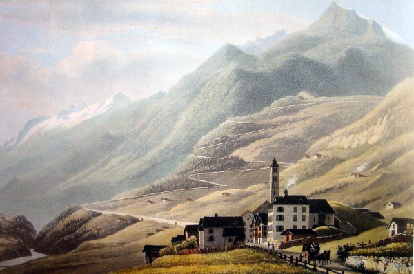
This
picture below is also Andermatt. Lovely.
|
 |
Rick's
European River Quiz
|
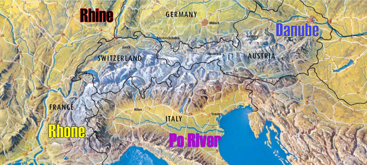
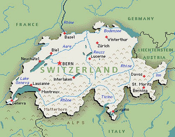
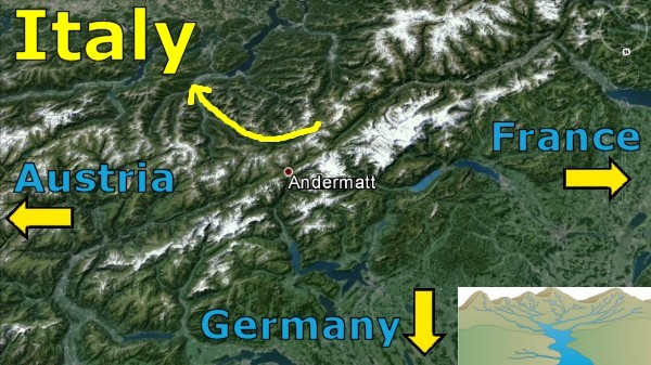
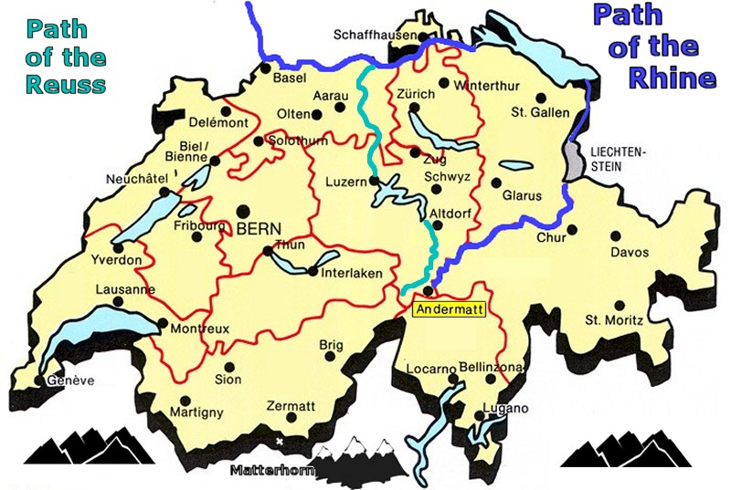
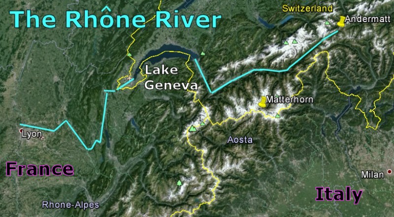
Any discussion of
European geography must begin with the Swiss Alps.
Switzerland is acknowledged as the water reservoir of
Europe. The snow melt and rainwater
descending from these mountains give birth to four
major Alpine rivers - Italy's Po, Germany's Rhine, Austria's Danube,
and France's Rh¶ne.
So how much do you know about Alpine rivers?
Here are some trivia questions. By the way,
expect to struggle. After all, you live in
America, not Europe. One of the major reasons many
of us like to
travel to Europe is to learn about
the parts of
the world our ancestors came from. Now let's see what
you already know.
Ģ
Question 01: North, East, South,
West... which one of these four directions gets left out in
the Alpine river sweepstakes?
Ģ
Question 02: Rhine, Danube, Po,
Rh¶ne... which of these rivers does not originate in the
Swiss Alps?
Ģ
Question 03:
Can you name the only
river originating in the Swiss Alps that empties its waters
into the Black Sea?
Ģ
Question 04:
What mountain range marks the eastern border of the
European continent?
Ģ
Question 05:
Var, Adige and Piave.
What is the significance of these three Swiss rivers which you probably
have never heard of?
Ģ
Question 06:
Aare, Thur, Reuss...
these rivers are tributaries of which major Alpine river?
(Hint: Look at the map)
Ģ
Question 07:
Durance, Dr¶me, IsĶre...
these rivers are tributaries of which major Alpine river?
Ģ
Question 08:
Sava, Drava, Mur, Enns,
Inn... these rivers are tributaries of which major Alpine
river?
Ģ
Question 09:
Oglio, Adda, Ticino,
Dora Baltea... these rivers are tributaries of which major
Alpine river?
Ģ
Question 10:
Are the Rhine and the
Danube connected?
Ģ
Question 11:
Can a boat go directly
from the North Sea to the Mediterranean Sea by crossing the
European continent?
Ģ
Question 12:
Here's a strange one. Out of the Big Four, which major
Alpine river has begun to steal the headwaters of which
other major Alpine river?
Ģ
Question 13:
There is one European river that appears in more
crossword puzzles than all the other European rivers put
together. Can you name it?
Ģ
Question 14:
Bug, Ill, Don, Ems, Lys, Oka, Tay, Alma, Avon, Kama,
Main, Oise, Ouse, Oder, Yalu, Yser... these are all legitimate
names of European rivers except for one.
Which is the odd river of the bunch? Can you guess it?
Ģ
Question 15:
Can a boat reach Stockholm, Sweden, from Istanbul
in the Black Sea without using the Mediterranean
Sea?
ANSWERS
01 - None of the four major rivers flow west.
02 - Surely you named the Danube, but did you remember
the Po? Both receive most of their waters from the Swiss Alps, but neither the
Danube or Po actually originate in the
Swiss Alps.
03 - The Inn River is Austria's longest river; it
flows through Innsbruck and connects to the Danube at Passau, Germany.
The Danube doesn't count because it starts in the
Black Forest.
04: The Ural Mountains of Russia separate
Europe from Asia.
05: The Var, Adige and Piave are the only
rivers originating in the Swiss Alps that do not connect to
the Rhine, Rh¶ne, Danube or Po. The Var empties into
the Mediterranean Sea very close to the Rh¶ne. The
Adige and Piave empty into the Adriatic Sea.
06: Aare, Thur, Reuss are tributaries of the
Rhine.
07: Durance, Dr¶me, IsĶre are tributaries of
the Rh¶ne.
08: Sava, Drava, Mur, Enns, Inn are tributaries
of the Danube.
09: Oglio, Adda, Ticino,
Dora Baltea are tributaries of the Po.
10: Are the Rhine and the
Danube connected? Yes. There is a twisty river called
the Main which winds its way east through the Black Forest
to connect to the Rhine. The Rhine-Main-Danube canal
connects these two major waterways near Nuremberg. There are
15-day trips that connect Amsterdam to Budapest.
11: I saw a listing for a Rhine-Rh¶ne river
cruise so I checked. There is a Rhine-Rh¶ne canal just
north of Basel which allows a riverboat to make it all the
way from the North Sea to the Mediterranean. It
connects the Rhine to the Doubs River which connects to the
Saone River which connects to the Rh¶ne.
12:
The
Danube sinkhole is an underground river which secretly steals water from the
Danube and gives it to the Rhine. This sinkhole is 10
miles east of the current source of the Danube. This is
known as "stream capture". The Rhine will someday completely own the
headwaters of the Danube and the Danube just have to find
someplace else to "begin".
13: If you solve crossword puzzles, then surely
you have heard of the Swiss river known as the "Aar" and the
"Aare".
14: The Yalu is a border river between North
Korea and China.
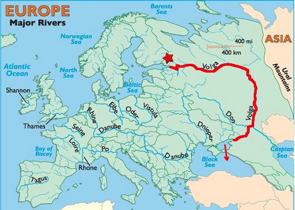
15:
The Europeans have
connected the entire continent via canals. That
includes the Russians who have created the Volga-Don
Waterway. This waterway connects the Neva River
of St. Petersburg (see
red star) on the edge of the
Baltic
Sea near Finland to the Volga, Europe's longest
river.
Believe it or not,
the ancient Vikings used to make the same trip in the
8th-11th centuries before there
were any canals!
(Russia
2012: Vikings)
a river cruise
leaving Istanbul in Turkey will take
28 days to reach St. Petersburg. By the way, don't forget to wave
at Vladimir Putin as you pass Crimea on the Black
Sea. They say war is God's way of teaching us
geography. That certainly is true of Crimea.
|
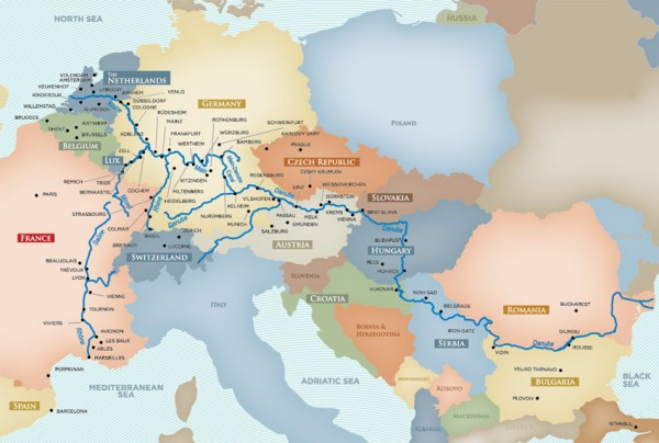
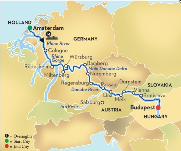
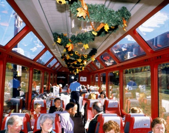
The
Rhine-Main-Danube Canal. It
takes 14 days to sail by riverboat from Amsterdam to
Budapest.
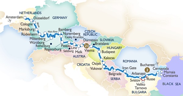
Once
upon a time there was the Orient Express linking Paris to
Istanbul. This modern 21-day river cruise from Amsterdam to
the Black Sea is virtually the same length as the train ride.
|
|
|
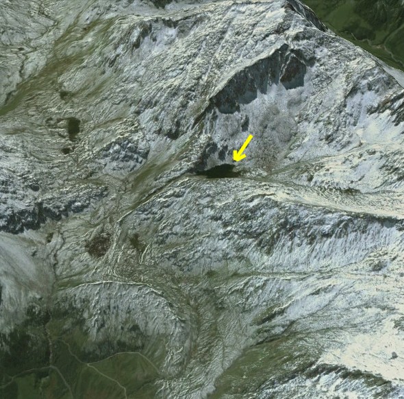
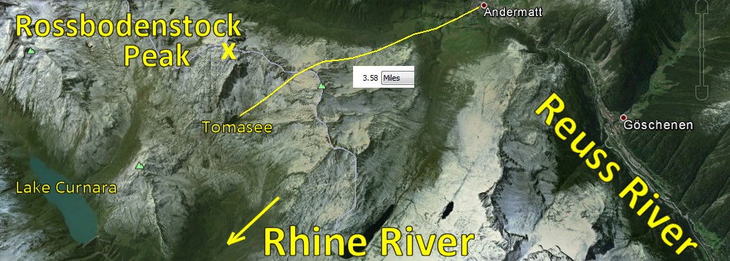
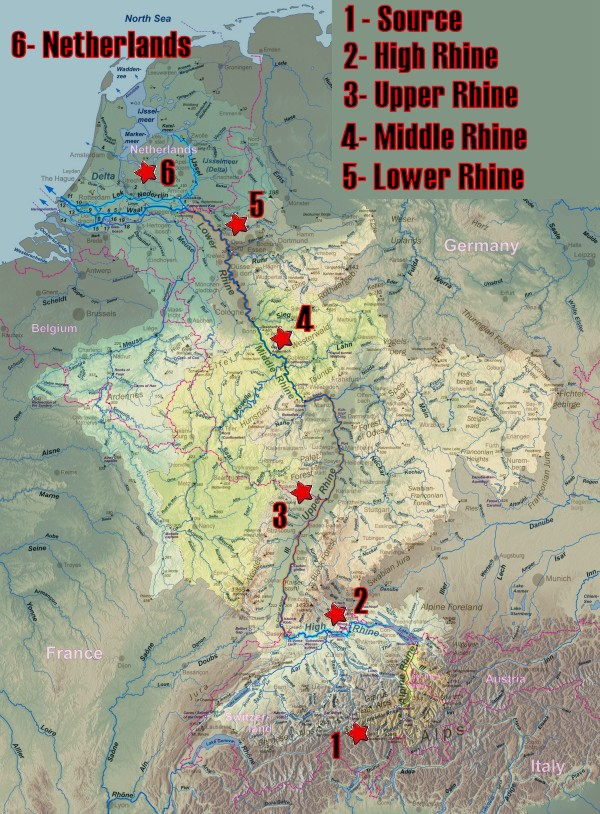
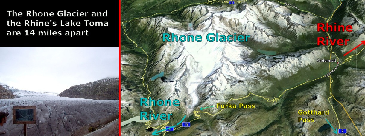
The
Source of the Rhine
River
Tiny
Lake Toma,
not even 200 yards wide, is the acknowledged source of the
Rhine
River.
If you are a bird, Lake Toma
is a mere 3.5 miles away from
Reuss River
in the next valley.
However, if
you prefer to hike, the trail from
Reuss River
via the
Oberalp Pass
is 6 miles.
The
peak of
Rossbodenstock is only a few hundred yards
away from Lake Toma. Depending on where the
snow falls on that peak, when it melts, the
snowflake will become the
Rhine
River or
the
Reuss
River.
The
Reuss River
runs straight through the lovely village of
Andermatt,
population 1,300.
As this article will make clear, if you have
a good raft, a nine mile walk from Andermatt
in any direction will get you a free ride to
the North Sea, the Black Sea, the Adriatic
Sea, and the Mediterranean Sea.
This assumes you don't mind going over the
occasional waterfall.
|
 |
|
|
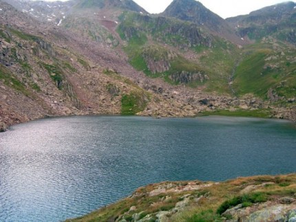
The valley
below
Tomasee (Lake Toma) is the acknowledged source of the Rhine.
That said, the waters of nearby
Lake Curnara also drain to the Rhine.
Indeed, there is a huge network of a dozen lakes and countless
brooks and streams that
should all be considered "sources" of the Rhine.
Lake Toma
gets the nod as "The Source" because it is higher than any
other contributing body of water.
Lake
Toma and Friends
The
Rhine River begins its 776 mile journey to the North Sea
high up in the Swiss Alps.
There is a wonderful web site titled
Riverama that gives an outstanding presentation on
the source of the Rhine.
The official source of the Rhine is at Toma Lake,
aka Lac de Toma (French), lai da Tuma
(Romansh), Lago di Toma (Italian) and Tomasee
(German).
Why five names? Since Switzerland is the center of a
wagon wheel of nations, every country has its own name for
Toma. Incidentally, "Romansh" is the
name for the Swiss language.
Lake Toma is 7,700 feet above sea level.
 |
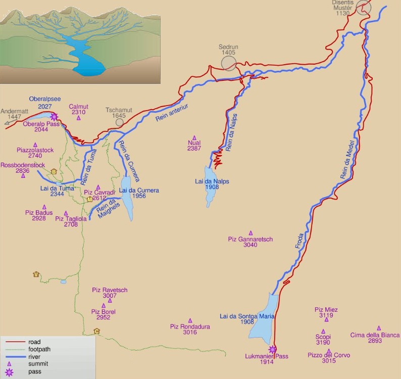 |
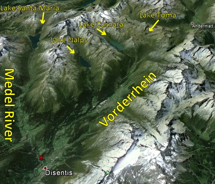
Vorderrhein
Everyone agrees that naming Lake Toma as
THE
SOURCE
is a bit of a joke. After all, Toma
is the smallest lake in a network of brooks and lakes that
contribute their waters to a Rhine tributary known as the
Vorderrhein
(Anterior Rhine: "Front Rhine")
The Medel River (map on right) is just as large as the
Vorderrhein. However, once its waters merge with the
waters coming down from Lake Toma, etc, at a town
known as
Disentis, the Medel River becomes part of the
Vorderrhein as well.
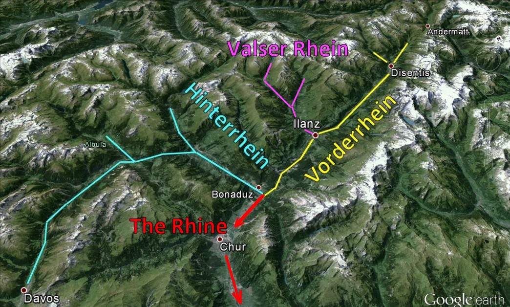
Hinterrhein
The Rhine is said to have two main tributaries: the
Vorderrhein
and the
Hinterrhein
(Back
Rhine).
Compared to the Vorderrhein, the Hinterrhein
(map below) is shorter in length but much bigger by volume. The rivers merge at the town of Bonaduz.
There is also a third tributary named
Valser Rhine
which merges with the Vorderrhein at Ilanz.
The map below gives an idea why the Vorderrhein is
considered the "front" part of the river.
Starting at Lake Toma near Andermatt, it keeps
a straight line.
|
 |
| |
I have
never figured out how they decide who the
"winner" is when two equal rivers meet.
One has to surrender its name. I suppose
it is like getting married... custom suggests
the lady yields
her surname in the man's favor.
When two
rivers meet, it seems like whichever river comes
closest to maintaining its original direction
gets the nod.
In this
case, neither "name" wins. After the
Front Rhine and the Back Rhine merge,
the
Rhine
name finally emerges on its own. |
|
 |
|
|
 |
The
map on the left does a nice job showing how the
Front
Rhine
and the
Back
Rhine
intersect. The map on the right shows how the
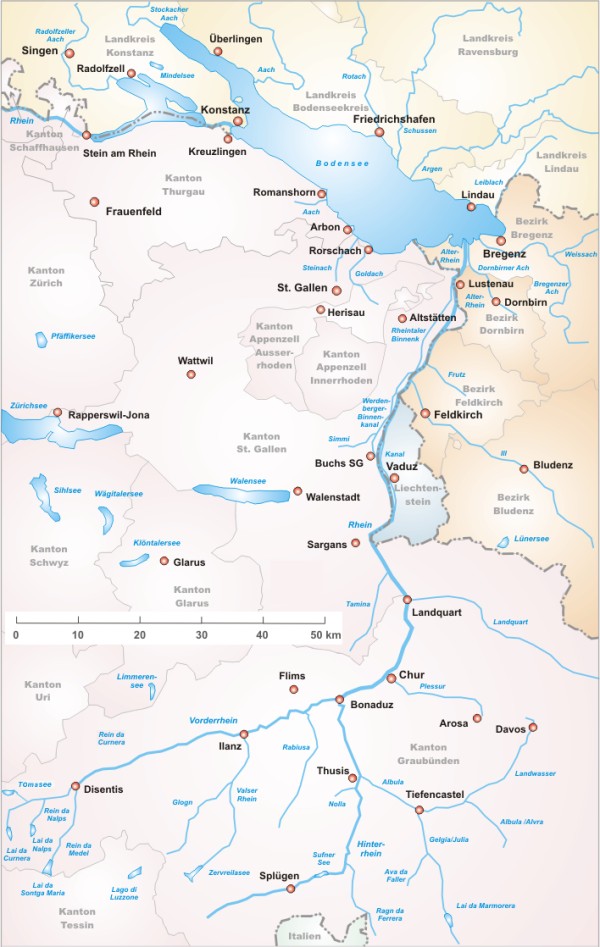
Rhine forms the Swiss border for Austria and Germany.
In the eastern part, the Rhine passes by the
tiny country of Liechtenstein.
|
Where will the Snowflake Go?
|
The Swiss Alps are the birthplace of many European
rivers. Interestingly, many of these rivers start
within a few miles of each other, sometimes even closer!
The picture on the
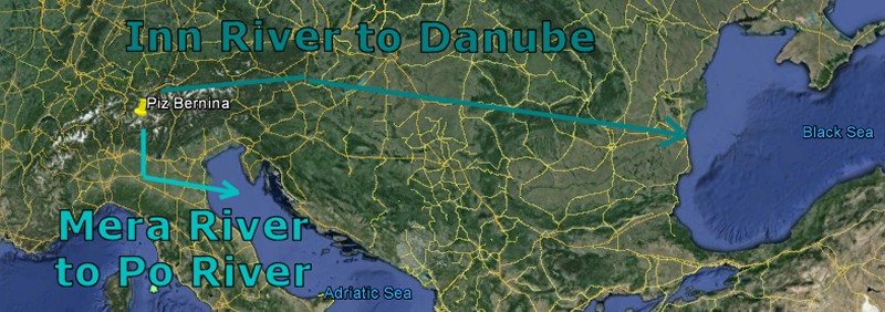
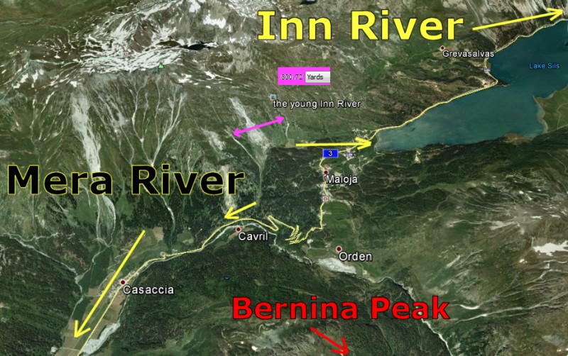
right shows the Inn River (flows through St.
Moritz and Innsbruck) entering the Danube.
The Mera River flows down to Lake Como. It
eventually connects to Italy's Po River via the
Adda River flowing from Lake Como.
The next map shows
two streams that are the source for the Inn and the Mera
that start 800 yards
apart and end up 800 miles apart.
I am not quite sure
why I am so fascinated by these Alpine Rivers, but it
tickles me no end to think that a snowflake that is
windblown a few feet in either direction can end up in
the Black Sea or the Adriatic Sea.
I found
several similar examples of adjacent river sources.
But first, here's a trivia question for you. The
sources of 2 famous United States rivers are only 12
miles apart in the Rocky Mountains. One ends up in
the Gulf of Mexico, the other in the Pacific Ocean.
Want to take a guess?
One of the things
that made it fun to search the Alps for river sources was Google Earth.
The valleys are so
dramatic - very wide and very deep - that it is easy to
spot a river's path within the maze-like Swiss Alps.
Earlier we studied
the source of the Rhine. Now let's look at other
rivers.
|
 |
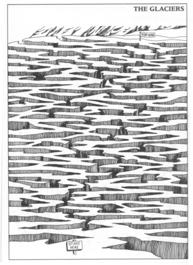
The
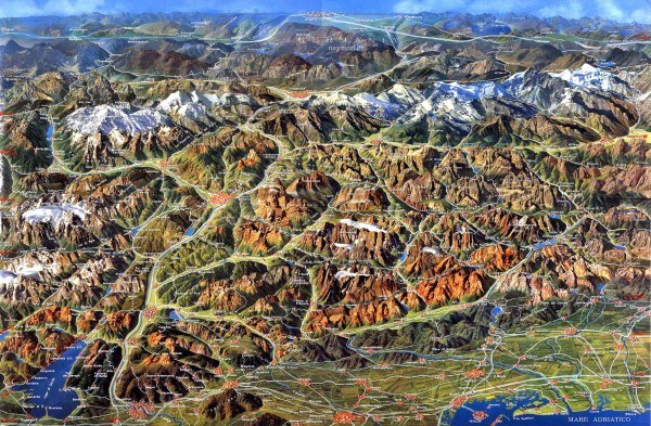
Amazing Maze-Like Valleys of the Alps
|
The moment I saw the picture on the right, I was struck
by how the valleys create a clearly defined Maze when
seen from above. I was reminded of a maze I once solved
known as The Glaciers.
By the way, it
isn't tough. Give it a shot!
Trivia Question
Answer:
30 miles due west of Fort Collins, Colorado,
the Colorado River and Kelly Creek,
a tributary of the North Platte River,
originate on either side of Clark Peak.
They are only 12 miles apart. This is
the only example I could find where the
Rocky Mountains spawn adjacent rivers like
the Swiss Alps. Do you know of any
others?
|
The Swiss have built an entire lifestyle around
their amazing valleys. Because they have so little
space that is habitable, they treat what they do have with
reverence.
So what creates
these valleys? The original volcanic eruptions
created ravines and depressions which have been enhanced
over the eons by river water. The
Swiss have lots of water. While the territory of
Switzerland represents a mere four thousandths of the
continent's total area, 6% of all Europe's freshwater
reserves are stored in Switzerland.
One of the
interesting features of these valleys is how
deep and well-defined they are looking down using
Google Earth. It helps me spot where a new
river must be.
For my next section
about the Valleys of Switzerland and their rivers, we
need to revisit Andermatt. If you recall,
Andermatt is a small village located in a valley high
in the south-central Alps just north of the border with
Italy. Its population is only 1,500.
As one can readily
see from the pictures, Andermatt is a stunningly
beautiful little village in a stunningly beautiful
valley. What makes Andermatt useful is that it within
walking distance of the source of the
Rhine.
We will be using Andermatt to help keep track of
various rivers.
According to
Wikipedia, Andermatt serves as a true crossroads
for both East and West as well as North and South.
Since the town is
surrounded by four major Alpine passes: the Oberalp
Pass to the East, the St. Gotthard Pass to
the South, the Furka Pass to the West, as well as
the G÷schenertal Pass to the North, Andermatt
is important for automobile travel.
Route 2
which goes straight through Andermatt is the most
important North-South road in Switzerland. It
connects Italy to Germany. Route 2 uses the famous Gotthard Pass which is 3 miles south
on the Italy side of
Andermatt. This vital artery connects the northern
German-speaking part of Switzerland with the
Italian-speaking part on the route to Milan.
In the old days,
cars had to drive over the pass. I can imagine
that was tough during snowfall. Fortunately these
days life is easier due the Gotthard Road Tunnel.
In response to the automobile boom in Switzerland and
the popularity of Italy as a travel resort, the Swiss
government gave approval in July 1969 for the
construction of the 16-kilometer Gotthard Road tunnel.
This would provide year-round road link between central
Switzerland and Milan to be used in place of driving
over the Gotthard Pass.
The Gotthard
Road Tunnel in Switzerland runs from
G÷schenen to Airolo, Italy. It runs 10 miles in length
below the St. Gotthard Pass. At the time it was
built, the tunnel was longer than any existing road
tunnel. Today it still the third-longest road tunnel in the world after
China's Zhongnanshan Tunnel and Norway's Lµrdal Tunnel.
Andermatt
is just as important for rail traffic. The Gotthard
Railway Tunnel was built 100 years before the
Road Tunnel. The two tunnels are parallel to each
other.
The Gotthard
railway is the Swiss trans-alpine railway line from
northern Switzerland to the canton of Ticino. The line
forms a major part of an important international railway
link between northern Europe, especially Germany, and
Italy.
At the moment, they
are expanding the railway tunnel in the heart of
the Swiss Alps. The new part is expected to open in 2016. With a route
length of 35 miles and a total of 94 miles of tunnels,
shafts and passages, it will be the world's longest rail
tunnel.
Getting back to
that theme of "space is precious",
I found it curious how precisely the Swiss measure
their environment.
Read this.
|
I just
can't get over how "maze-like" the mountains and valleys
appear from above. Every one of the deepest valleys has
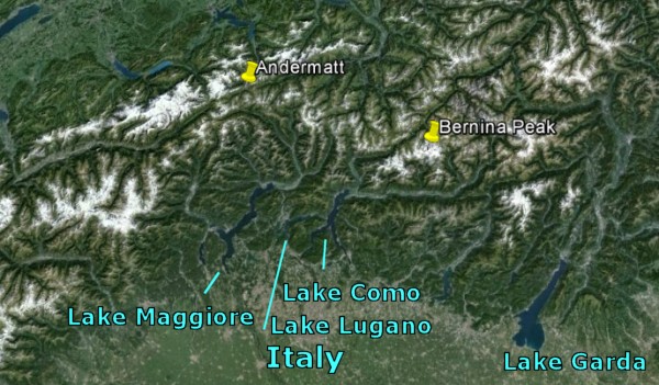
a river important to the Swiss. As you can see, the
southern part of the Alps drains into a series of large,
beautiful lakes in northern Italy.
Maggiore, Lugano, and Como drain to the
Po
River.
Lake Garda drains to the
Adige
River.
Sixty
percent of Switzerland is mountainous. Like the people
of the Andes and the Himalayas, the Swiss find a way to
build homes.
Every
Swiss valley has a river. Follow the river and you will
find a village.
The Swiss
have no choice. Where there's a valley, there's a village.
|
Andermatt
has an area of 24 sq miles. Of this area, 40.8% is
used for agricultural purposes, while 5.5% is forested.
Of the rest of the land, 1.7% is settled (buildings or
roads) and the remainder (52%) is non-productive
(rivers, glaciers or mountains).
In the
1993/97 land survey, 0.4% of the total land area was
heavily forested, while 5.1% is covered in small trees
and shrubbery. Of the agricultural land, 4.3% is used
for orchards or vine crops and 36.5% is used for alpine
pastures.
Of the
settled areas, 0.5% is covered with buildings, and 1.1%
is transportation infrastructure.
Of the unproductive
areas, 0.5% is unproductive standing water (ponds or
lakes), 1.0% is unproductive flowing water (rivers),
there is 30.9% that is too rocky for vegetation, and
19.7% is other unproductive land.
Living space is so
precious and tight that the Swiss measure precisely to
the inch. They make conscious decisions how much is farm
and how much is forest.
Can you imagine
calling "flowing water" unproductive?
They have so much water they just want to get rid of it!
Meanwhile there
seems to be no wasted space in the Swiss valleys.
Every single spot of farmable land is cherished dearly.
|
Isn't
it amazing how this valley seems almost "carpeted"?
To me, one difference between Rocky Mountain valleys and
Swiss valleys is how much "greener" the Swiss valleys are.
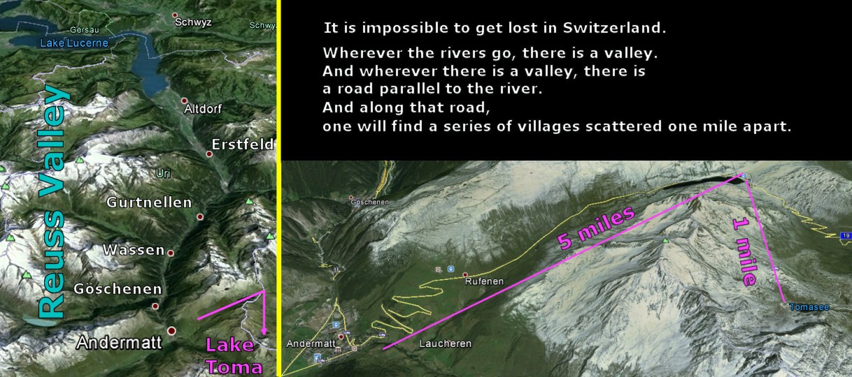
There
is an amusing rumor that it is impossible to get lost in
Switzerland. No matter where you go, there's bound to
be another village a mile away or one you can see from the
top of a mountain. First find a mountain, then find a
valley. Within one mile you will find a village.
Andermatt's valley
is the perfect example. First comes
Andermatt
is
followed by
G÷schenen
further down the road which followed by
Wassen,
Gurtnellen,
Erstfeld,
and
Altdorf.
|
From:
Bill Devine
Sent: Sunday, November 6, 2016 1:46 PM
To: rick@ssqq.com
Subject: Yellowstone & Snake Rivers
Hi Rick,
I was reading your article ōSwiss Riversö on ssqq.com/travel
today. ItÆs a long story how I ended up there, but IÆm glad
I did. The article was very informative and very
interesting. Part way thru, you had a trivia question:
Trivia
Question Answer:
30 miles due west of Fort Collins, Colorado, the
Colorado River and Kelly Creek, a tributary
of the North Platte River, originate on either
side of Clark Peak. They are only 12 miles
apart. This is the only example I could find where the
Rocky Mountains spawn adjacent rivers like the Swiss
Alps. Do you know of any others?
I wanted to answer, but you didnÆt include an email
address. But I finally tracked you down.
Yet another example of where the Rocky mountains spawn
adjacent river like the Swiss Alps is in northwestern
Wyoming. In the southeastern corner of Yellowstone NatÆl
Park, two important rivers start their lives just a few
miles away from one another in the Absaroka Range on the
Continental Divide. They are the Snake and Yellowstone
Rivers. The Snake flows 1,040 miles west to the Pacific
(after joining the Columbia), while the Yellowstone flows
east 692 miles before it joins the Missouri River, which
later joins the Mississippi and flows into the Gulf of
Mexico.
Even more interesting is the story of Isa Lake which I read
about years ago in a travel guide ¢ FrommerÆs, I think. I no
longer have the guide book, but hereÆs what I wrote in my
post-trip journal:
| |
|
My Favorite Lake
You would naturally
assume that my favorite lake would be either Lake
Jackson or Lake Yellowstone, right? Wrong. My
favorite lake was Isa Lake.
Bet you never heard
of it! And with good reason. ItÆs the saddest
excuse for a lake IÆve ever seen. If truth be
known, itÆs really a small puddle. In fact, the
first two attempts I made to locate it ended in
failure. But I still love it! Tiny though it is,
itÆs not insignificant: it sits astride the
continental divide at Craig Pass, a place that,
while 8,262 feet high, is nonetheless quite flat.
So flat, in fact, that water flows out both ends of
this ōlake.ö
Now, while that is a
bit unusual, itÆs not exactly earth-shattering.
What is exciting (to me anyway!) is where that
overflowing water goes to. You see, water flowing
out of one end of the lake flows into the Pacific
Ocean, while water flowing out of the other end
eventually reaches the Atlantic.
But, thatÆs not all!
ItÆs the water that flows out of the west end of the
lake that later flows east into the Atlantic, and
the water flowing out of the east end of the lake
that reaches the Pacific!
|
Isa Lake at Craig Pass
|
|
A Valley
in The Swiss Maze
Reveals a Mystery River
|
Over the years, I have had more fun than a boy should be
allowed playing with Google Earth. Google
Earth is sheer magic. For this story, Google
Earth allowed me to visit a Swiss valley so intimately I
felt like I was almost there.
If I had one small complaint, Google Earth does not
like rivers. For the life of me, I cannot find any
function that labels the river names.
It drives me crazy, especially because my story is about the
Rivers of Switzerland.
However, on the other hand, the "Not Knowing" made for a
wonderful game while writing this story. I see a valley. Therefore there
is a river. What is the name of the river?
Then I go over to Google Maps which does label the rivers.
After finding the right spot on Google Maps, I can identify the river in question.
Now my next goal is to
figure out where it begins. Using Google Maps,
I trace the river to its source. Then I go find the
spot spot on Google Earth. While researching
this story, I went through this same procedure SIX TIMES!
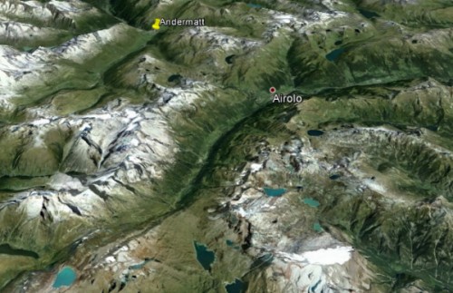
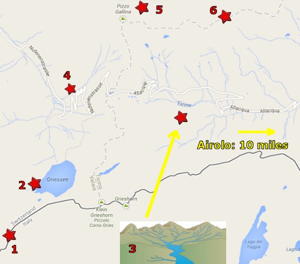
Would you like to play along with me? As one can see,
in the area around Andermatt, there are all kinds of
valleys. I made it my goal to identify the river in
each valley.
In the map on the right, there is a curvy valley just above
"Andermatt". I went ahead and filled that valley in
with a yellow line. As one can see, the valley is
heading south towards Italy. I
have no idea what the hidden river might be, but I am
curious.
Looking at the map, my first clue is
that Airolo is part of the mystery valley. So I
Google "Airolo".
I learn that Airolo is a small Swiss town 7 miles due
south of Andermatt. Airolo is separated from
Andermatt by giant mountains known as the Lepontine Alps.
I learn that there is a pass through those mountains known
as Gotthard Pass. I also learned that Airolo is the starting point
for the Gotthard Pass Road Tunnel that goes
underneath those mountains.
And I also
find what I am looking for: The name of the river of this valley is the
Ticino River.
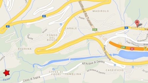
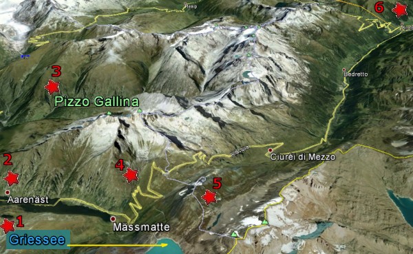
Please look at the map on the right. Using Google Maps, I
have traced the Ticino River
to its source (Red
Star 3).
Using my map ruler, I find that the source of the Ticino
River is 10 miles to the west of Airolo.
Then I study the area. I learn is that we are really
close to the Swiss-Italian border (Red Star 1).
The second thing I learn is the largest lake in the picture
is Griessee (Red Star 2). Lakes are useful because
Wikipedia usually has a listing for most lakes. I
file that away for later.
Notice the small blue streams around the Red Star 3.
Each stream is a tiny tributary. They all come
together to form the headwaters of the Ticino River.
In dealing with the Rhine and now the Ticino,
I realized that a river rarely has one particular spot as its source, but rather
a spider web network of small brooks and streams that seek
the lowest point in the valley.
Red Star 4 is where I identified "Nufenen" as
the likely name of the mountain pass that marks the start of
the Ticino River. "Nufenenstrasse"
is German for Nufenen Street.
Red Star 5 indicates that the largest Alpine mountain
in the area is Pizzo Gallina. It took me a
while to figure this out, but the words Piz, Pix,
and Pizzo represent the English word "Peak".
Red Star 6 shows a dotted line represents
the highest ridge of a series of Alpine peaks.
As I would come to learn, when two snowflakes fall on the
opposite side of a dotted line, they end up floating down
different rivers going in opposite directions.
PLEASE LOOK AT GOOGLE
EARTH MAP OF THE SAME SPOT
Armed with this Google Map information, now I go back to Google
Earth.
Red Star 1 in the Google Earth map is Griessee, or Lake
Gries.
Red Star 3 is Pizzo Gallina, or Gallino
Peak.
Red Star 6 shows Airolo in the distance.
As usual with Google Earth, there is no sign of the river name.
However, where there is a
valley, there will be a river and a road. That yellow
road surely parallels the Ticino River.
Red Star 5 shows a faint white line that denotes the upper ridge of a
chain of mountains. Earlier this same white was a
"Dotted Line" in Google Maps. This white line crosses
Nufenen Pass
and heads over to Gallina Peak, then on to the entire chain
of the Lepontine Alps which parallel the valley.
Now I decide it is time to learn more about the Ticino
River, so I
Google "Ticino" and find its Wikipedia listing.
The Ticino
river is a river that originates in the Alps, near
Nufenen Pass. It then flows through the Swiss canton of
Ticino and northern Italy. The Ticino river flows
through Lake Maggiore, then later it flows into the
river Po, near Pavia. It is 270 km (167 miles) long.
The Canton (State) of Ticino is the southernmost canton
of Switzerland. Named after the Ticino river, it is
the only canton where Italian is the sole official
language and represents the bulk of the
Italian-speaking area of Switzerland along with the
southern sections of Graub³nden.
In ancient times, the area of what is today Ticino was
settled by the Lepontii, a Celtic tribe.
Later, probably
around the rule of Augustus, it became part of the Roman
Empire. Ticino
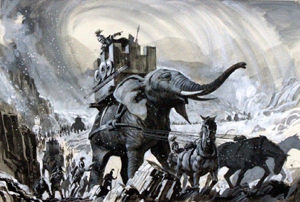
was the location of the Battle of Ticinus, the
first battle of the Second Punic War fought between the
Carthaginian forces of Hannibal and the Romans under
Publius Cornelius Scipio in November 218 BC.
After the
fall of the Western Empire, this area was ruled by the Ostrogoths,
the Lombards and the Franks.
In the
15th century,
the Swiss Confederates conquered several valleys south of
the Alps in three separate conquests. At this
time, the lands now occupied by the "Ticino Canton" were annexed from
Italian cities. The lands of the canton
of Ticino were the last lands to be conquered by the
Swiss Confederation
Okay, so now I know why all the names along the Ticino sound
Italian... this area was once Italian. I imagine that
chain of mountains known as the Lepontine Alps was
once the borderline between Switzerland and Italy.
This tidbit explains why most of Switzerland speaks German,
but the region south of the Lepontines speak mostly
Italian... sort of the same reason why half of Texas, USA,
speaks Mexican.
I
also learn that the Ticino River is the most
important tributary of the Po River coming from the
Alps.
I
knew that Hannibal had crossed the Alps with his
elephants to attack Italy, but it gave me goosebumps to
realize this valley was the actual location of a major
battle. Very cool.
Nufenen
Pass is the second highest mountain pass with a
paved road within Switzerland. It lies between the
summits of Pizzo Gallina (north) and the
Nufenestock (south).
The pass road from Ulrichen in canton of Valais leads to
the Bedretto valley in the canton of Ticino,
linking Brig to Airolo.
The pass is of relatively recent construction, having
been opened to traffic only since September 1969.
There is a
spectacular view to the southwest of the Bernese Alps
(Eiger, M÷nch and Jungfrau peaks) notably the
Finsteraarhorn while there is a view over the
Gries Glacier to the south.
To the east of the top of the Nufenen Pass is the source of
the Ticino River.
I
have learned 3 new things. First, the name of
the Ticino River valley is Bedretto.
Second, the source of the Ticino is confirmed.
Third, I just got an
idea. Each Pass seems to mark the start of a valley.
Now I realized that I might find river sources by looking for mountain
passes. Hmm. I already knew the Oberalp Pass
marked the start of the Rhine River. Now I have just
learned the Nufenen mountain pass led to the
Ticino River. What about Gotthard Pass?
What did it lead to? And Furka Pass?
|
This
historical picture shows the Swiss town of
Airolo
has a distinctive "Italian" look to it and that it is
located at the foot of Gotthard Pass.
Red
Star 3 identifies the name of my mystery river. The
source of the
Ticino
turns out to be 10 miles to the west of Airolo.
This
Google Earth Map shows what the Red Stars look like when
seen from a bird's eye view.
Bedretto Valley. The white capped mountain at the top
of the picture
marks Nufenen Pass, the source of the Ticino River.
And just where is our star river in the picture? One
needs to remember it is a baby river that was just born a
couple miles further up the valley. I have little
doubt there is a stream hiding there in the shadows.
Once I
confirmed that "Nufenen" was the name of the pass where the
Ticino finds its source, I Googled "Nufenen". That is
how I learned there are FOUR MAJOR MOUNTAIN PASSES in the
Andermatt area. I already knew about Gotthard, Oberalp,
and Nufenen... but what about this
Furka
Pass?
Hmm.
|
|
Another
Mystery
River
in the
Swiss
Maze |
 |
|
Neufenen
Pass had given birth to the Ticino River.
Oberalp Pass had given birth to the Rhine
River.
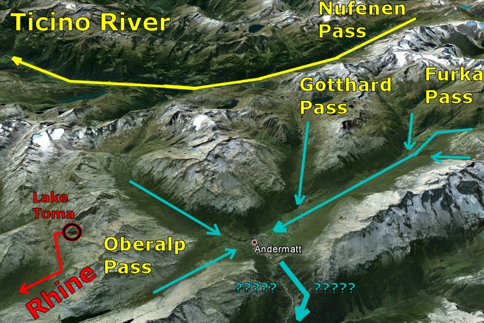
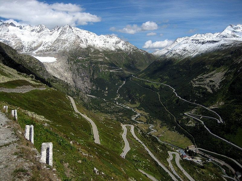
What about
Gotthard Pass? And what about Furka
Pass?
So
I took another look at Gotthard Pass. Its waters
clearly would go straight to Andermatt.
The
more I stared at Andermatt, I realized it was in the
center of an unusually large valley with six distinct
valleys aimed right at it. It crossed my mind that
each of those 6 valleys had to
be sending serious amounts of water toward Andermatt.
So I Googled "Andermatt Valley".
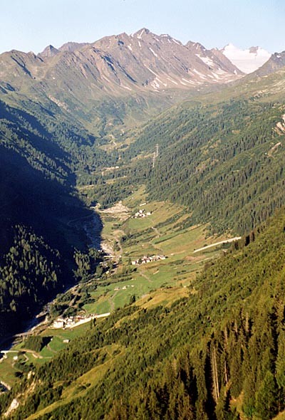
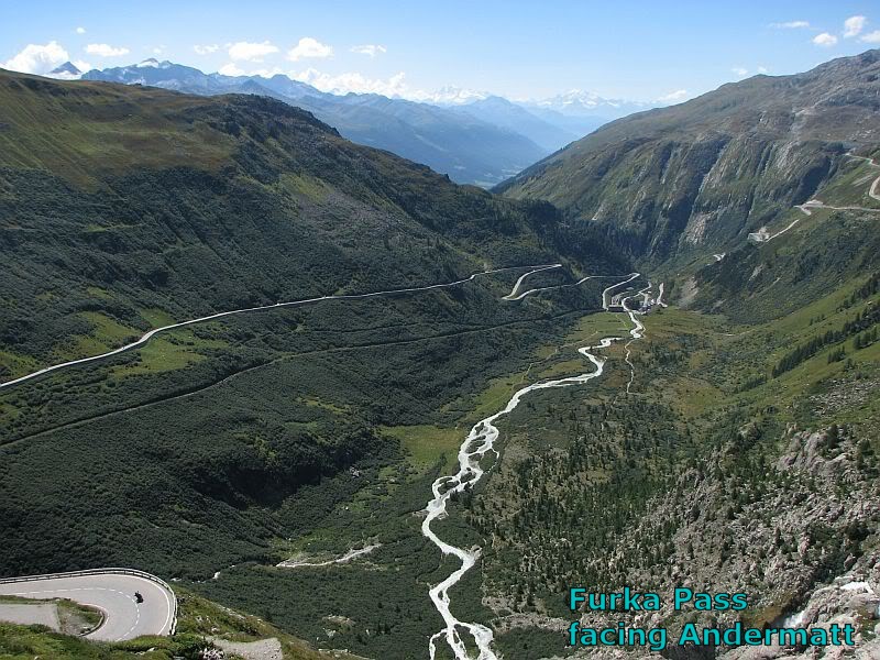
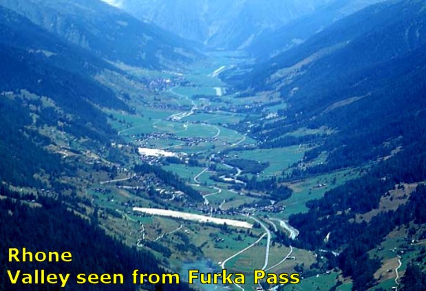
Below is a picture I found.
Those winding roads at the top center of the picture plus the length of the valley helped me
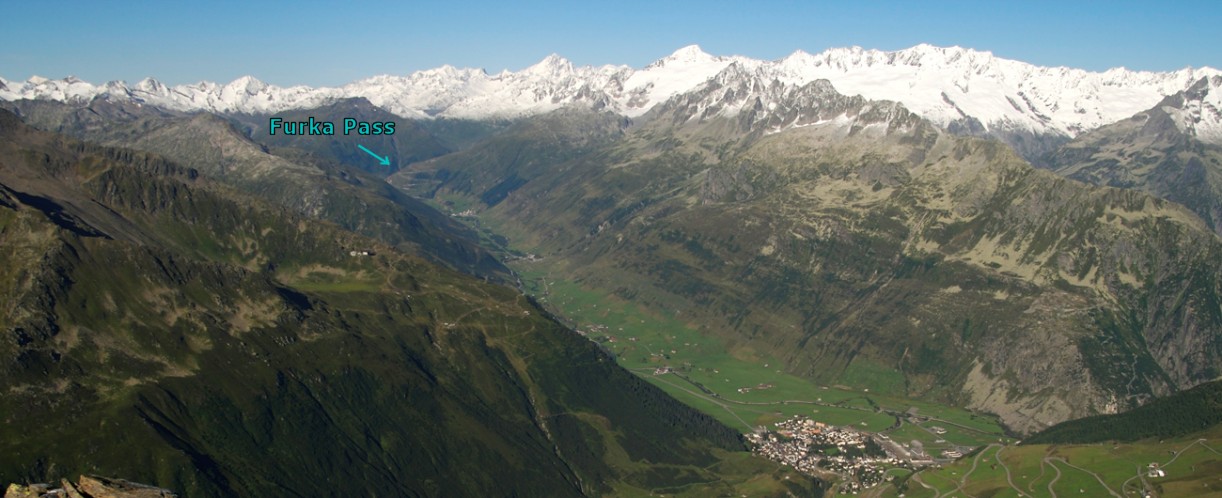
figure out that was Furka Pass.
I wonder what river
goes from Furka Pass to Andermatt?
|
 |
 |
|
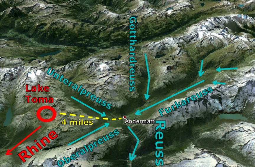
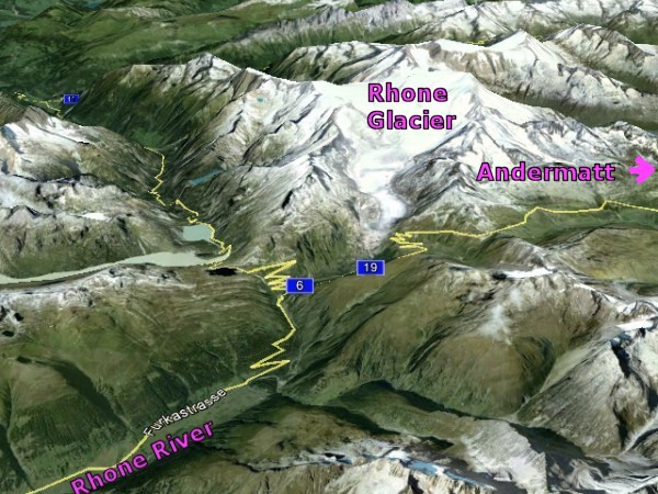
Since I knew exactly where Andermatt was on Google
Maps, it didn't take long to figure it out.
The newest mystery river was the
Reuss River.
The Reuss had
four major tributaries: The Furka Reuss, the
Gotthard Reuss, the Unteralp Reuss and the
Oberalp Reuss.
All four merged in or near Andermatt and reemerged
from Andermatt as one river.
I
learned that the long valley to the right (west) of Andermatt
is
called the Furka Valley.
Furka Valley is a
typical Swiss valley... long, narrow, a road following the
river banks, and one new village every mile or so.
|
The valley south of Andermatt is the Reuss Valley.
The Reuss Valley features the Gotthard Railway
which crosses north to south through central Switzerland.
It is
the main artery between Germany, Switzerland, and Italy.
I
thought it was interesting to find that Lake Toma,
the source of the Rhine, and Andermatt, the
source of the Reuss, are just
four miles
apart at the Oberalp Pass.
From above, the deep valleys certainly resemble a maze.
So is it possible to get lost in this maze?
We know that Water will always find a way out, but could
someone get totally disoriented and go hopelessly astray?
Cheer up. No one can get lost in Switzerland.
Just go downhill till you find something.
|
 |
|
|
|
 |
The
Snowflakes of the Reuss and Rhine
|
Here is the Reuss River going straight
through Andermatt.
Earlier we learned
that two Swiss rivers -
The Inn and the Mera - start 800 yards
apart and end up 800 miles apart.
The Reuss
and the Rhine do just the opposite. After
starting more or less side by side in Andermatt, they will
merge a long way away on the other side of Switzerland.
Even without a map
or any signs, I believe you and I could be dropped from
the sky into Andermatt and be able to find the
edge of Germany without any trouble.
In fact, I think it
would be easy. All we have to do is find the river
of the valley and head DOWN. How hard is that?
In fact, we could
separate and follow our own river with the intention of meeting again
in North Switzerland.
Since the Swiss
love to hike, you and I could each hike
along the path of the river.
|
 |
|
Since this was my
idea, I get first pick. I would pick the
Reuss and follow the river through the valley till
it connected to the Rhine on the German border.
Since it is a
direct downhill shot 70 miles away, I might just get a
float and pretend I am the Swiss Huck Finn.
As for you, since I
am a good sport, I would let you have the famous
Rhine.
You would begin by climbing 5 miles up the
Oberalp Pass... hard work I would imagine.
Then you could walk over to Lake Toma and begin
following the Rhine around the east side of
Switzerland.
I suppose I would
have enough time to enjoy a couple beers till you got
there. Your trip would be 160 miles.
|
 |
|
 |
 |
|
Another
Mystery
River
in the
Swiss
Maze |
 |
|
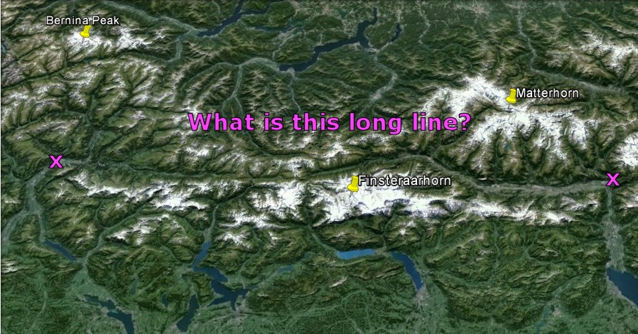
When I stared down at
the maze of valleys from above, there was one formation that
was impossible to overlook.
There was a deep trench that extended across
practically the entire
width of Switzerland. Switzerland is not a large
country. It is 137 miles at its longest north to
south point and 216 miles wide. I measured the
trench. It came out to 130 miles.
From the sky, it looked
like one long river. I
stared and stared and finally I had to know what it was.
|
| |
So I zoomed in with Google Earth.
I
gasped with delight. I had just made a grand discovery
It turned out that this long stretch was not one river, but
two.
To the east was the Rhine River.
To the west was the Rh¶ne River.
I
was certain I
was looking at
the Rhine and
the Rh¶ne with their
backs to
one another. |
|
 |
I started with Google Earth by zooming in at
Andermatt.
I quickly
discovered I was looking at the Rhine in one
direction, so I reversed direction. I went to the
end of the Furka Valley and stumbled on a huge
set of pictures posted on Google Earth at the
Furka Pass.
The first picture I
clicked said "auf dem Rh¶negletscher".
Obviously this was
something called the Rh¶ne Glacier. That wasn't
difficult. Now it was time for Wikipedia.
The
Rh¶ne Glacier (German: Rh¶negletscher) is a
glacier in the Swiss Alps and the source of the
river Rh¶ne.
The
glacier is a primary contributor to Lake Geneva
in the far eastern end of the Swiss canton of
Valais. Because the Glacier is located close
to the Furka Pass road, it is easily
accessible.
I was so proud of
myself. I had accidentally located the source of
the
Rh¶ne. Unlike the Ticino and the Reuss
which had required at least some digging, the Rh¶ne
gave itself up quickly.
So there it is.
That's a picture of the Rh¶ne Glacier. One
can also see some of the road at Furka Pass and
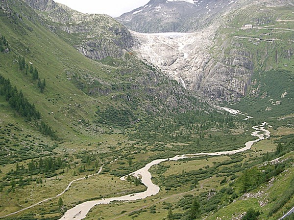
the beginning of the Rh¶ne River.
I loved that
picture until I learned a disturbing fact. Because
the highway is perched just a few feet from the side of
Switzerland's largest glacier, this kind of
accessibility also makes the Rh¶ne Glacier Switzerland's
most researched glacier.
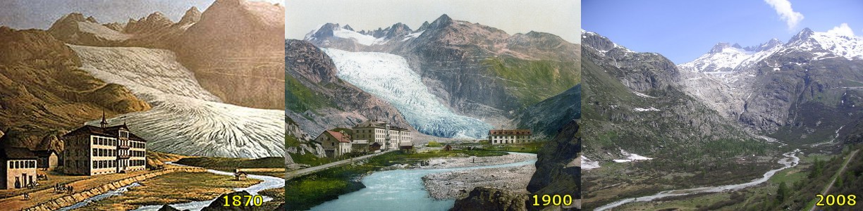
The evolution of
the Rh¶ne Glacier has been observed and measured since
the 19th century. In the old days, the glacier extended
deep into the valley. Not any more. The
glacier lost 1300 meters of ice and snow during the last
120 years, leaving behind a track of naked stone.
Look for yourself.
|
 |
 |
As one can see, the
Rh¶ne heads towards the Matterhorn and Lake
Geneva in the SW corner of Switzerland.
The Furka Pass
and the Rh¶ne Glacier is located nine miles west
of Andermatt. The
ridge along nearby Furkahorn Mountain acts as a
watershed divide
A watershed
zone is the water drained by a main river plus
all its tributaries.
The five largest
river basins (by area), from largest to smallest, are
the Amazon basin, the River Plate basin (Uruguay), the
Congo basin, the Nile basin, and the Mississippi basin.
The three rivers that drain the most water are the
Amazon, Ganges (India), and Congo rivers.
The
Mississippi watershed ranks fourth. No
European River comes close to matching the
Mississippi River, not even the Danube or the
Volga.
|
 |
 |
 |
Andermatt
seems to be in the middle of everything. Every
road, every pass and every river - Rhine,
Rh¶ne, Reuss, and Ticino.
Now it turns
out that our friend Andermatt is situated
right on the spot where the snowflakes have
their choice of 3 directions - North (via
the Rhine and its tributary the Reuss),
Southeast (via the Po and its tributary Ticino),
and Southwest (Rh¶ne)
By the way, there are a lot of snowflakes that fall in
Andermatt. Andermatt
receives heavy snowfall.
I believe there are two ski resorts in the area.
If you are curious, here's an interesting story
on
skiing in Andermatt. It turns out
Andermatt has its share of problems too.
Don't we all?
|
|
 |
|
Furka Pass
|
 |
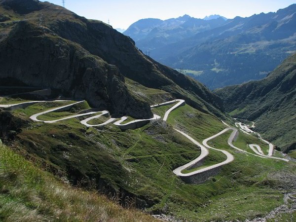 |
Furka Pass is an interesting place.
I am fascinated by the thought that a
snowflake changing its course by a few
feet could end up in one of two spots
600 miles apart.
Since the Reuss
River ends up connecting with the Rhine River on the
north side of Switzerland, that means any snow falling
east of Furka Pass goes to the frigid North
Sea in Rotterdam or Amsterdam via the Rhine River.
Aufwiedersehen!
Since the source of
the Rh¶ne is on the west side of Furka Pass, it
gets to float down the Rh¶ne and take a vacation
in the warm, sunny Mediterranean Sea at
Marseilles, France.
Personally, if I am a snowflake, I am
doing whatever I can to make to the
Mediterranean Sea side of the Furka
Pass. Au Revoir!
And
if that snowflake drifts six miles south
to the Ticino River, it would end
up in the Adriatic Sea via the
Ticino, Lake Maggiore, and
the Po River. Arrivederci!
|
 |
|
 |
 |
|
|
|
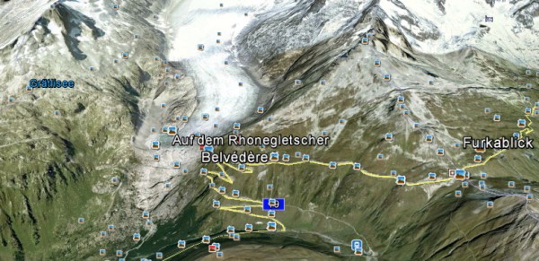
While I was poking
around the Internet for more information about Furka
Pass and the Rh¶ne Glacier, I came across this picture.
It was taken by a
man on a motorbike who was crossing all the different mountain
passes in the area.
This picture was
captioned:
"Taken
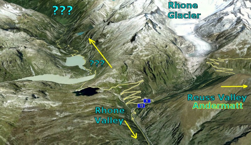
from Furka Pass on way to Grimselsee Pass"
I
knew the word "See" was German for "Lake". Obviously
that was Lake Grimsel. But I had never heard of
Grimsel Pass before. Where is Grimsel Pass?
Better check it out. Wikipedia, Map or Google Earth?
I decided to try Google Earth first.
|
 |
|
I went to Google
Earth and zoomed in on Furka Pass. To my
consternation, I noticed that Furka Pass was a
lot more complicated than I had realized.
Right past the
Rh¶ne Glacier, the Furka Pass forked off in
two directions. One direction led to the Rh¶ne
Valley.
The other direction
led to some dark place. Would could that be?
Now it was time for Wikipedia.
Wikipedia had two
paragraphs on Grimselsee Pass. Here is one of them:
Grimselsee Pass connects the valley of the river
Rh¶ne in the canton of Valais with the Haslital
(upper valley of the river Aar) in the canton of
Bern. It is located near the source of
the Rh¶ne at the Rh¶ne Glacier.
The Aar
River? Oh, be still my beating heart!!
They must be talking about the
Aare River!! The
Aare River has been my favorite river in the world for
the past 20 years. I will explain why shortly.
I
had no idea the Aare River was in this vicinity. I
had not even been looking for it.
My original reason for visiting Switzerland via Google
Earth had simply been to
take a look at the Rhine.
And now look what I
stumbled upon... my favorite river in the world.
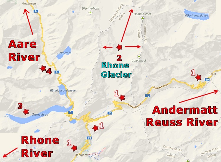
Now it was time for
Google Maps. The first thing I noticed was that
Furka Pass did indeed branch off to the north (Aare)
as well as the south (Rh¶ne).
The second thing I
noticed was that the Rh¶ne Glacier seemed to be
encircled on the three sides by dotted lines.
If I interpreted
that correctly, Furka Pass was wider than I realized.
It had to cross the Rh¶ne glacier to get to the other
side.
So I went back and measured it. Holy
cow, that glacier was 3 miles wide!
The third and
fourth thing I confirmed was that my newest mystery
valley was indeed the home of the Aare and that Lake
Grimsel was considered the true source of the
Aar.
|
Here is a closer look at Furka Pass. The area between
the two sets of jagged lines (those are roads), is three
miles wide. There is some very unusual geology in
this picture of Furka Pass.
It turns out this exact spot is the source of not one,
not two, but THREE different rivers -
Rh¶ne,
Reuss,
and now the
Aare River.
If the snowflake falls to the right, it goes to the
Reuss. If it falls in the middle, it goes to the Rh¶ne.
If it falls to the left, it goes north down the Aare.
 |
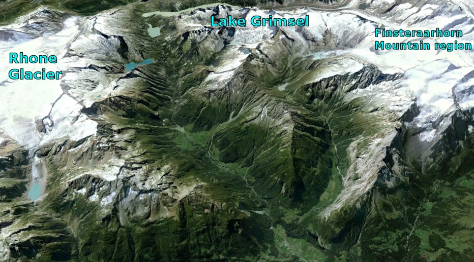
Using Google Earth, I
studied the Aare Valley.
Unlike the other valleys, this one was not green and vibrant
with a series of charming little villages spaced one mile
apart.
In fact, when viewed from above, the entire valley seemed deserted.
When I zoomed in, I discovered the valley is very narrow.
In fact, the upper part is so rocky that it features a road
and a river and not much else.
Consequently there is almost no farmland, thus very little population.
The upper Aare is a very rugged place indeed; it is quite
reminiscent of areas in the Rocky Mountains.
|
 |
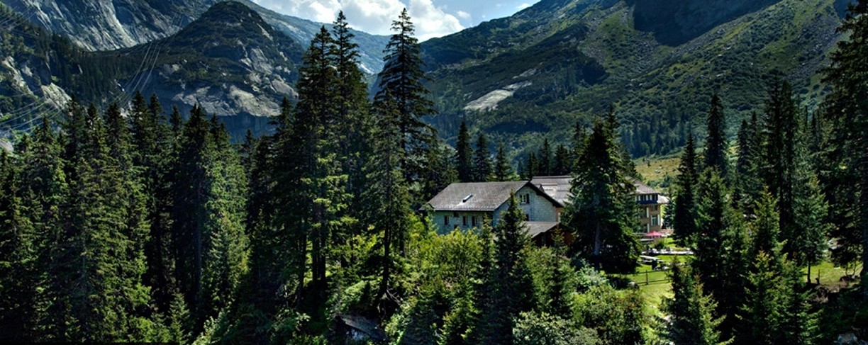
About two miles down
from the Grimsel Pass is the Handeck Hotel
(pictured above). This hotel is
a lovely Swiss
resort that looks like a pretty cool place to stay at.
The hotel is the ideal starting point for hikes and
mountaineering tours. You will pretty much have the
mountains and the forests to yourself. Since there are
no towns anywhere near this place and this place is really
hard to get to, the area is practically deserted. You could
probably hike naked and no one would notice.
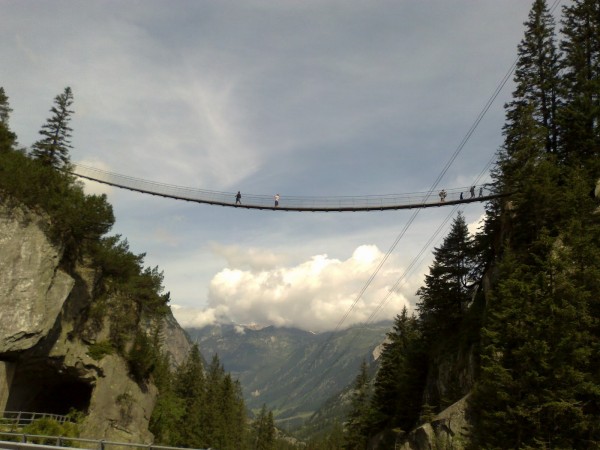
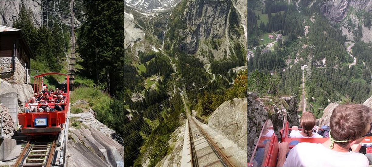
The hotel features a spectacular swing bridge that crosses
the valley. But that bridge is tame compared to the Gelmer funicular.
A
funicular is a cable railway in which a cable attached to a
pair of tram-like vehicles on rails moves them up and down a
steep slope; the ascending & descending vehicles
counterbalance each other. I imagine once you see the
pictures you will think twice about trying it - the Gelmar
is the steepest
funicular in Europe.
If you are curious, I found some pretty pictures of the
place to entice you.
Hotel Handeck
|
 |
 |
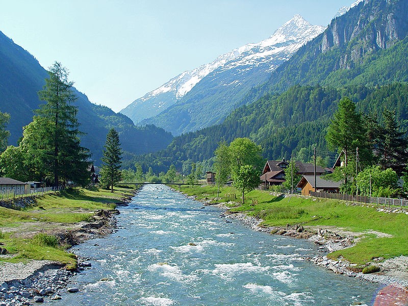
Here is a picture of the Aare near Innerkirchen. What
a place! Until this spot, the Aare was practically
deserted.
It was five miles from the top to reach the first village.
Guttanen was a little hamlet with only 300 people.
It turns out that the upper part of the Aar River is so
desolate one might consider it "Heidi-Land". There is
the occasional chalet or cottage up in some mountain nook.
It's a good place to practice your yodeling.
However, once you get to Interkirchen and
Meiringen 10 miles down from the top, you get into a
wide valley featuring Lake Brienz.
There is some pretty amazing scenery in this area. For
starters, there are the Bernese Alps featuring
Finsteraarhorn and an array of other superstar peaks.
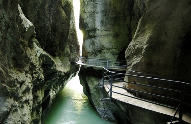
There is an unusual area known as the Aare Gorge that
is interesting. The entire river has cut a tunnel in the
soft rock and flows through that narrow hole.
And wait till you see the fortress on top of Reichenbach
Falls! OMG!!
|
 |
|
 |
 |
 |
 |
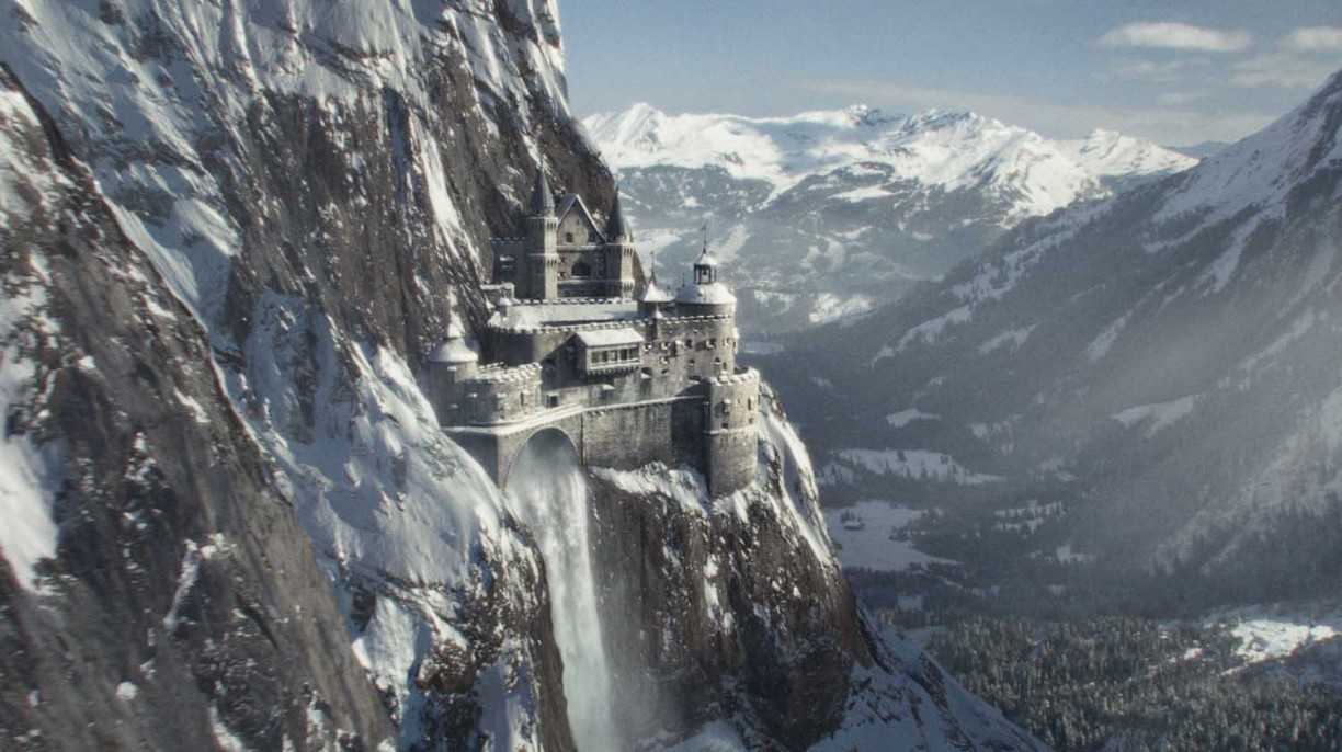
So did
your jaw drop? Mine sure did. Unbelievable.
This fortress over Reichenbach Falls looks like something from
Lord of the Rings.
Actually
this is indeed computer-generated art created by the VFX company
Framestore. This imaginary fort atop the Reichenbach Falls
was used in the movie 'A Game of Shadows'. They copied
elements of real castles and blended them in with this picture
of the falls near the Aare River.
|
Tale of Two
Rivers -
The Aare
and its Murderer |
 |
|
|
|
Rick's Note: If I have one
regret about our Rhine trip, it would be the fact that I
will miss seeing Switzerland's Aare River, my
favorite river. By they way, both spellings
(Aar-Aare) are correct.
More than likely, most readers will ask
themselves why anyone like me who lives in Houston, Texas, should care about some obscure river
practically no one has ever heard of.
Obscure? I think not. Tell that to someone from
Switzerland. The Aar, or Aare, is
actually the longest river in Switzerland. More water
drains from the Alps into the Aare than drains into
the quite famous Rhine.
For that matter, inside
the borders of Switzerland, the Aare is by far the
bigger river than the Rhine. The Aare is
Switzerland's favorite river to play in. There are
countless river tube tours that travel down the Aare
as well as a hugely popular bike trail that follows along
the river's path.
So if the Aare is so damn important, then why is the
Rhine famous and the Aare practically unheard
of outside the borders of Switzerland? Well,
that's a sad tale we will get to shortly.
The first question to ask is why I like the Aare
River so much. I give my daughter Samantha all the
credit. It was through her torture of her mother
during childbirth that I got hooked on crossword puzzles...
and it all started with the Aare.
In 1991, Samantha's mother Judy went into labor at 8 am.
Judy labored... and labored... and labored. This went
on forever. That darn kid wouldn't come out!
I couldn't leave the room... the baby might pick that exact
moment to make the final descent.
So I was stuck there for...
get this... 15 hours! Sam did not make her move till
11 pm that night. But no one has ever given me an
ounce of sympathy. I suppose that is because whatever small
discomfort I felt was magnified a million times for Sam's
mother.
My biggest problem was that I was bored. Make that
bored out of my mind. When Judy said, "take me to the
hospital NOW!" at 8 am, I grabbed the morning paper
and got in the car. Bad move. I should have
grabbed War and Peace instead.
I
finished the paper at 9 am. Now what? I have
nothing to read.
So I did a couple of puzzles in the paper to pass the time.
That took all of 10 minutes. Finally I began to stare
at the Crossword Puzzle. I had never done a Crossword in my life. Too busy.
Desperate for something to do, I began the Crossword puzzle.
It was harder than I expected! My progress was slow; this puzzle really
challenged me. Normally I would
have quit and walked away. But this was the only game
in town, so I stuck to it.
What really irritated me was there were all sorts of
questions that left me baffled. I distinctly
remember one question that irritated me no end. The
question was "River to the Rhine".
I
took German in high school. One of our projects was to
draw a detailed map of the country. I knew the Rhine
like the back of my hand. I remembered
the Neckar, Moselle and the Main were
the most important tributaries of the Rhine.
However, the crossword puzzle name mysteriously started with
"AA _ _". What could the
answer be? I agonized over this clue. Mind you, there wasn't any Internet to use
to look it up.
To my eternal frustration, I
never did completely finish that first puzzle. Furthermore it was not
until the answers appeared in the next day's paper that I
got my answer. The Aare River? Never
heard of it. I looked
it up in the Encyclopedia. Sure enough, there it was.
The Aare was the longest river in Switzerland.
No fair! I had memorized German rivers, not Swiss
rivers. But I did like the fact that this Crossword
puzzle had forced me to learn something new and interesting.
Hmm. The Aare River.
Sometimes I walk away from challenges that intrigue me. Golf,
Guitar, Trivial Pursuits, Billiards, Surfing, Yo-Yos and
Hula Hoops are activities I wanted to try, but passed on.
But this crossword puzzle had definitely gotten my
attention. To make a long story short, by the time Sam
finally decided to enter the world, I was hooked on
Crossword puzzles. I
began to do the crossword every day. It was my
new project. I found I could give Sam her bottle with
one hand and
study the Crossword puzzle with the other.
To my surprise, the Aare River popped up in another
crossword the following week. Surely this was more
than a coincidence. That was my
first clue that there is a special crossword vocabulary. As I
came to learn, the 7 most common letters are
e*t*a*o*i*n*s.
Note that four of those letters are vowels. So certain
short vowel-laden words become very useful to
connect the larger words on a recurring basis. The
Aare is one of these special words
So I sat down and memorized a list of 300 useful Crossword
clues like AARE, ESNE (an Anglo-Saxon slave),
ERNE (sea
eagle), TERN (bird), UTE, OTO, CREE (Indian tribes),
ISAR, ISER, ISERE, YSER, ODER,
EDER, and ELBE (more European rivers).
Sam is 22 now. At this point, I suppose I am pretty good at crossword puzzles.
Crossword Puzzles have given me great satisfaction over the
years... and I owe it all to the AARE River.
So imagine my disappointment when I learned the sad truth
about the Aare. Like brave Hector, hero of
Troy, for a brief time the Aare would achieve great
glory only to meet a cruel fate.
I looked at a map (see below). In a manner similar to
the Rhine and the Rh¶ne, the Aare and the Rhine were
born within ten miles of each other high up in the Swiss
Alps.
One
headed east, one headed west.
The two rivers were destined to meet again 100 miles away on
the opposite side of the country for the big showdown.
Only one would survive.
As the Aare made its long journey
through Switzerland, one river after another merged with the
Aare and surrendered its waters. In fact, in a little
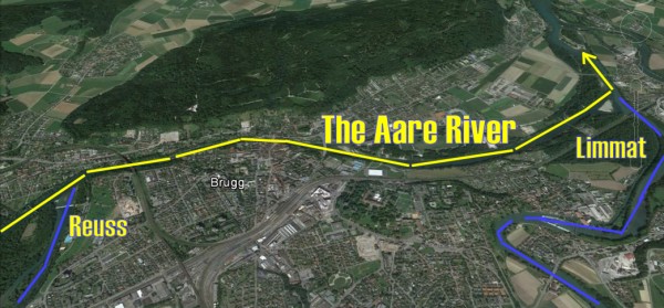
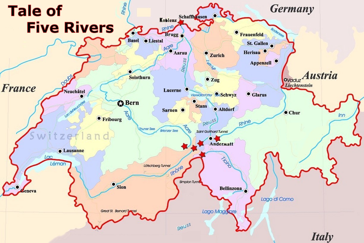
town named Brugg, within the space of two miles, two
major rivers - the Reuss and the Limmat -
merged with the Aare to create a super river.
Alas, the glory of the Aare would be short-lived. Just a mere 8
miles past Brugg, the Aare would find its
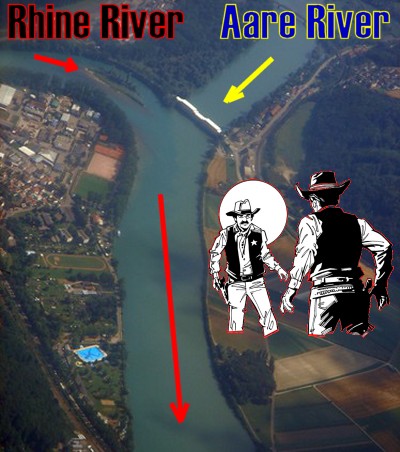
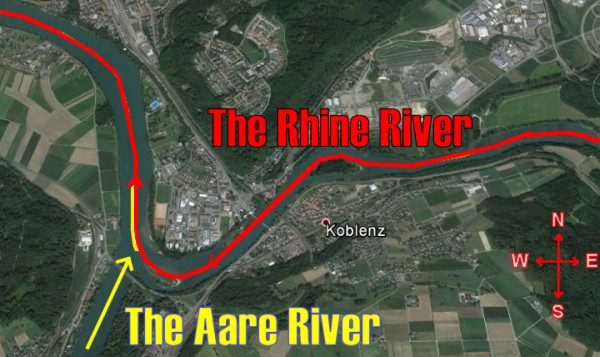
nemesis waiting. At the Swiss town of
Koblenz
on the
northern border of Switzerland and Germany, the Aare had a head-on
collision with the Rhine.
The collision did not go well for the Aare.
Even though the Aare was much larger, like David and
Goliath, this made no difference. The Rhine
got the inside edge and won the fight.
This was the
conclusion in the Tale of Two Rivers.
The Rhine had defeated the Aare. Like
mighty Achilles, the Rhine would go on to achieve worldwide fame.
Like the vanquished Hector, the Aare would disappear into
obscurity and crossword puzzles.
|
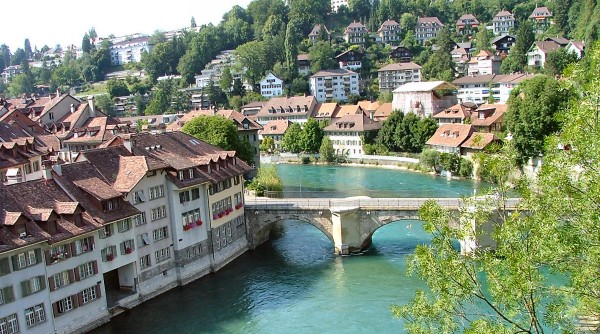
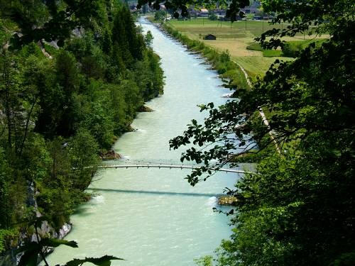
Switzerland's Rhine River hugs the eastern and northern
border of the country. Meanwhile, the Aare River cut a
path straight through the heart of the country. Here
is a picture of the Aare as it flows through Bern, capital
of Switzerland.
Not one
week goes by without spotting the Aare in a Crossword Puzzle
The glory
moment of the
Aare at
Brugg.
The merger
of the
Reuss and
Limmat
turns the
Aare
into a super river.
This glory would be short-lived. 8 miles away the
Rhine
awaits.
Tale of
the Two Rivers - Gunfight at the Koblenz Corral
The name 'Koblenz' comes from Latin
confluenza
- flow together
Actually,
I am not quite sure why the Rhine won the fight.
In this picture, it looks to me like the Aare has the better
angle.
|
Do I dare
admit I care
about a river so fair
as the sparkling Aare?
|
On a journey so rare
It was hard to prepare
to see my Aare
go nowhere.
|
Could I only have taught her
Beware of the other
Thy death by Rhine water
was unfortunate slaughter. |
|
|
|
Furka Pass
Revisited
|
It has been a long journey to this point, but I think we
have reached the end.
My story about Swiss Rivers began with my desire to locate
the source of the Rhine River.
My
original research led me to Andermatt since it was located
just six miles from Lake Toma, source of the Rhine.
The more I stared
at Andermatt using Google Earth from above, the
more curious I became about the unusual valley patterns
in the area.
The first unusual
pattern near Andermatt led me to the Ticino River
and the Nufenen Pass.
Next I noticed a
long trench that seemingly stretched unbroken across the
entire country of Switzerland.
My curiosity about
that trench led me to Furka Pass and the
discovery of both the Rh¶ne and the Reuss.
And then a random picture led me to the Aare.
|
 |
The
discovery of the Aare was pivotal. It made me
realize that Furka Pass, not Andermatt, was the
true focal point of the water distribution for three major parts
of Europe.
Furka Pass is three miles wide. Within those three
miles, three major rivers are sourced. The Reuss
(Switzerland's fourth largest river) and the Aare (second
largest) head north. The Reuss goes right through
the center of the country while the Aare winds through
the western part.
Meanwhile the Rhine (largest river) makes its debut in
Lake Toma 13 miles to the east and takes a roundabout path
through the eastern part.
The
Reuss and the Aare started three miles apart. They
will merge at Brugg in the northern part of the country.
8 miles further north, the Aare-Reuss will merge with the
Rhine.
|
 |
 |
Meanwhile the Rh¶ne starts at Furka Pass and heads
southwest.
The
Ticino starts five miles to south of Furka Pass and heads
southeast.
Thanks to its abundant supply of water, Switzerland has many
rivers and lakes. All major cities have their origin in the
strategic advantages of their water related location for both
trade and defense. Rivers Rhine, Aare, Rh¶ne, Reuss and Ticino
are Switzerland's largest rivers. They all originate in the
center of Switzerland's alps.
As
the picture below shows, these five rivers - Rhine, Rh¶ne,
Reuss, Ticino, Aare - form a remarkable cluster.
All
five rivers start within 13 miles of each other. That's
pretty incredible.
I
hope you have enjoyed my story about the Swiss Alps and the
Swiss Rivers.
Rick Archer
March 2014
|
|
 |
|
|