GUOLIANG MAPS
Written by Rick Archer
October 2009
|
|
For the record, the correct coordinates
for Guoliangcun are
35�43'52.64"N, 113�36'13.77"E |
|
|
 |
FORWARD
Assuming you
read the Search for Guoliang,
you are well aware that this small village has been
misplaced all over China!
During my
research, I counted at least seven different provinces with
a "Guoliang", including Tibet, Sichuan, Chongqing, Shanxi,
Shaanxi, Hunan, and of course Henan.
Since there
has been so much confusion, the purpose of adding these maps
is to allow other people to pick up the trail and confirm
the work I did.
I helped lose
the place, so I am now determined to help find it!
If you do take
the time to retrace my steps and discover an error, by all
means contact me. I am committed to clearing up the
confusion and welcome all the help I can get.
Rick Archer
dance@ssqq.com
|
 |
During my
three day search, I had been tricked by so many false "Guoliangs"
that I was still suspicious about the place I had designated
as the ONE TRUE GUOLIANG.
I made a
decision to use all three maps - Google Earth, Google Maps
and Maplandia - in conjunction with each other to
double-check my work.
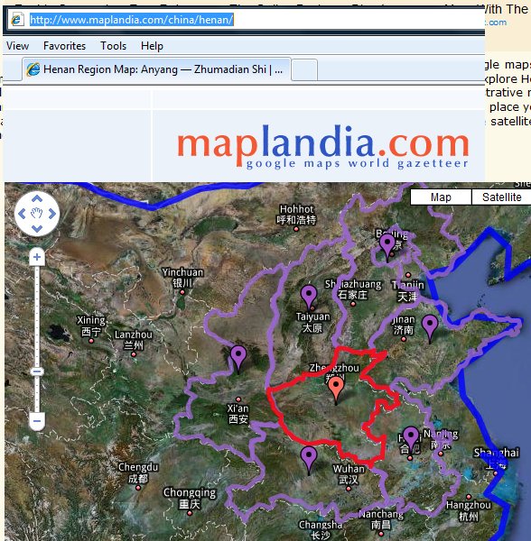
MAPLANDIA
Maplandia
is an odd service provided by Google. It is a cross
between Google Earth and Google Maps.
Maplandia
starts off like a map, but when you zoom in close enough,
you start to see the same satellite imaging you get in
Google Earth.
In this
particular "Maplandia" map, you see Henan Province along
with its capital city Zhengzhou. Now you have
the Big Picture
|
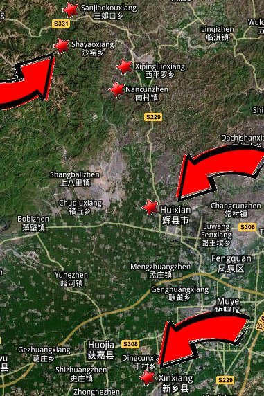 |
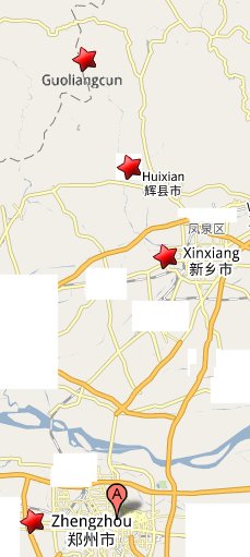
In this
particular "Maplandia" map, you see the two starting points
- Xinxiang and Huixian - in reference to Shayaoxiang, the
village nearby Guoliang.
The map on the
left illustrates Provincial Road S229, aka the Road
to Guoliang.
The map on the
right gives a closeup look at my original search area.
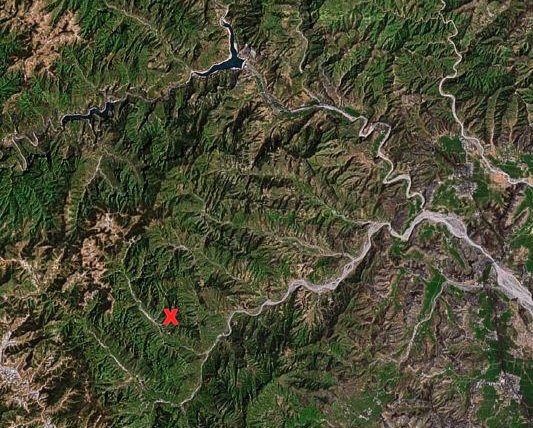
The
Red X
marks Guoliang. The search area is defined by two
distinct rivers. One of my great frustrations was my
inability to locate a name for either one.
The north-south river connected to the Sanjiaokouxiang
Reservoir at the top of the picture.
The Road connecting S229 to Guoliang followed alongside the
East-West river.
|
 |
|
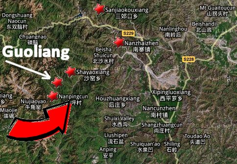 |
I never
located Guoliang using Maplandia. However I did run
across one useful clue.
Nanping
(or Nanpingcun ) was mentioned in some of the blogs I
read as being a village very close to Guoliang.
"We
had only planned to stay 1 night here
(in Guoliang), so the next morning we caught a
taxi to the next village,
Nanping, where we got on various buses -
Nanping to Huixian to Zhengzhou and the final change our
next destination, Song Shan Mountain."
As you can see
in the picture, I was able to locate Nanping using
Maplandia.
|
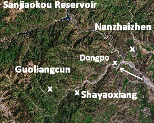 |
If you decide
to retrace my steps, you will do well to locate what I call
the East-West and the North-South Rivers. Both rivers
served as obvious reference points.
Provincial
Road S229 was The Main Road to Guoliang as far as
I was concerned.
At a certain
point near Nanzhaizhen, there was the "Second Road
to Guoliang" that branched off to the west from
Provincial Road S229. The Second Road to
Guoliang ran through a long valley parallel to the
East-West River.
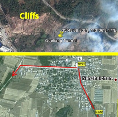
Nanzhaizhen
was the town that was closest to the connection of the
north-south and east-west rivers. One mystery that I
never solved was the exact spot where the bus would turn
from Provincial Road S229 to go to Guoliang.
At first I
assumed it would be Nanzhaizhen because there was a
clearly marked road heading west. Later on, however, I
noticed a smaller road that might serve as a possible short
cut to Dongpo located along the East-West River.
I will cover
this in more detail when we get to a better map.
|
 |
FINDING
GUOLIANG
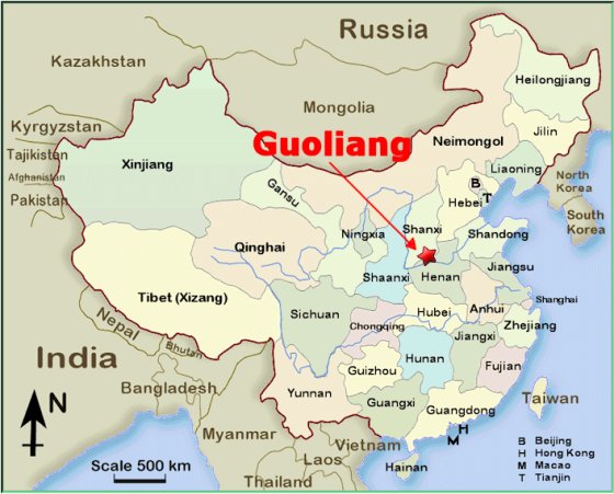
As I read all
the blogs, Zhengzhou, Henan's capital, Xingxiang,
and Huixian were listed as the three most likely
departure points on any trip headed to Guoliang. The
distance from Zhengzhou to Xinxiang is 42
miles. The distance from Xinxiang to
Guoliang is 44 miles.
Therefore the
distance to the small village of Guoliang from Zhengzhou,
the capital of Henan Province, is 86 miles.
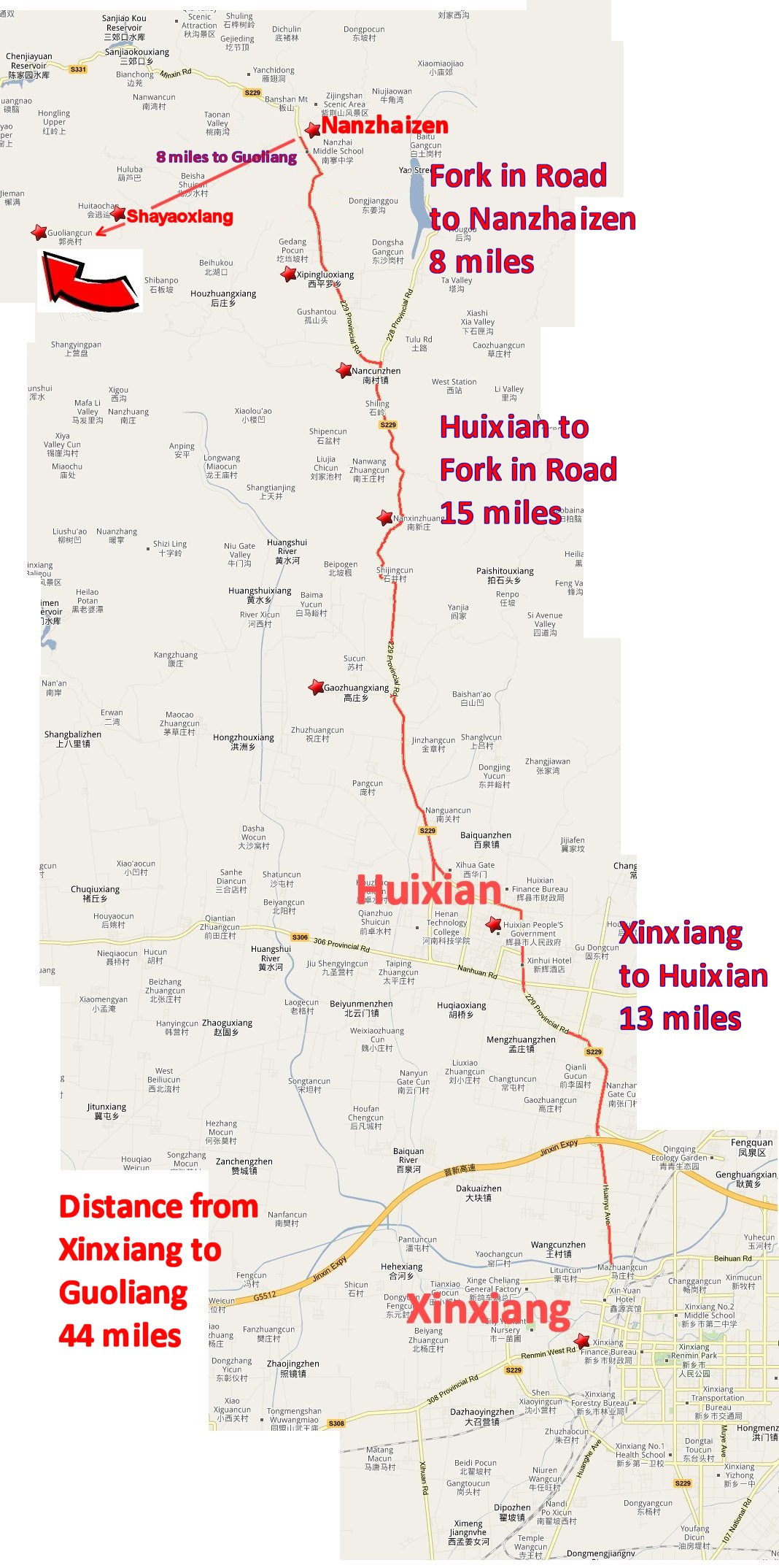
Using Google
Earth, I have placed an enormous picture which will show the
route to Guoliang. S229 is the Main Road to
Guoliang.
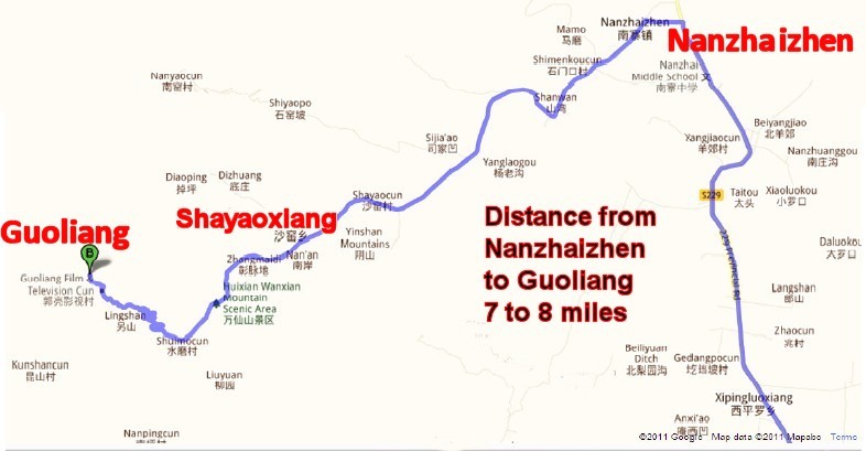
S229 takes you Xinxiang to Huixian, a
distance of 13 miles. The distance from Huixian
to Nanzhaizhen is 23 miles. The Turnoff Road
from Nanzhaizhen to Guoliang is 8 miles
further.
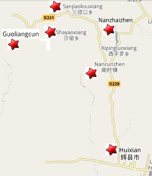
Just to give you an overview, here are two small snapshots
of the area you are about to survey. Please be
aware that at any time you can bring up Google Earth and
retrace my steps without trouble.
Finding those
towns using Google Earth was pretty tricky sometimes. They stayed
invisible unless you either knew where to look or stumbled
across them. Be sure to click "Populated Places" and
"Roads" on your SIDEBAR for wonderful extra information.
|
 |
When you open
Google Earth, you can go directly to Guoliang by pasting
these coordinates:
35�43'52.64"N, 113�36'13.77"E
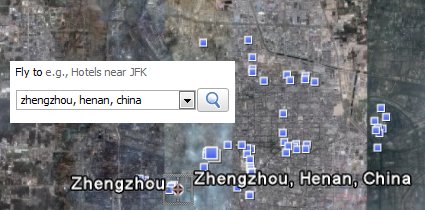
Or you can
explore by starting at Zhengzhou, the capital. Start
by typing in "Zhengzhou,
Henan, China". Theoretically Google Earth will
take to the picture you see on the right. From there,
head north and zoom in till you find Xinxiang.
After Xinxiang, now it is time
to look for Huixian which is ten miles north of
Xinxiang.
Huixian
might be tricky to find. You will have to zoom in.
For example, after I found Xinxiang, I had to click
eight times before the name "Huixian" appeared.
Once you find Huixian, you should be ready to match
the screen that you see on Google Earth to my picture below.
|
 |
One warning
- you will be surprised at how "invisible" many of
the villages stay unless you are at the correct focus level.
You won't see those towns listed in white shown below unless
you take the time to zoom in at the EXACT SPOT.
SUGGESTION
- If you go "split-screen" with my Internet Page
and Google Earth, you can put the two pictures side by side.
This trick will allow you to retrace my giant picture below
and see both screens at the same time. That will make
it easier to find things.
|
|
 |
Now it is time
for another giant map. Our new map is a Google Map
view of the same area as the Google Earth picture
above. The Google Map picture below is a
different way of looking at the Google Earth picture
above. I did this to give me two looks of the same
place. I used this technique as my way to double-check
my work. Guoliang was hard enough to find.
Let's not lose it again. Plus this time I intend to
make there are no more mistakes!
|
|
 |
Distance between each segment
(according to
Google Maps)
Zhengzhou to Xinxiang: 42 miles
Xinxiang to Huixian: 13 miles
Huixian to S229/S228 Fork in Road (stay to the left on
S229): 15 miles
S229 Fork in the road to Nanzhaizen: 8 miles
Nanzhaizen to Guoliang: 8 miles
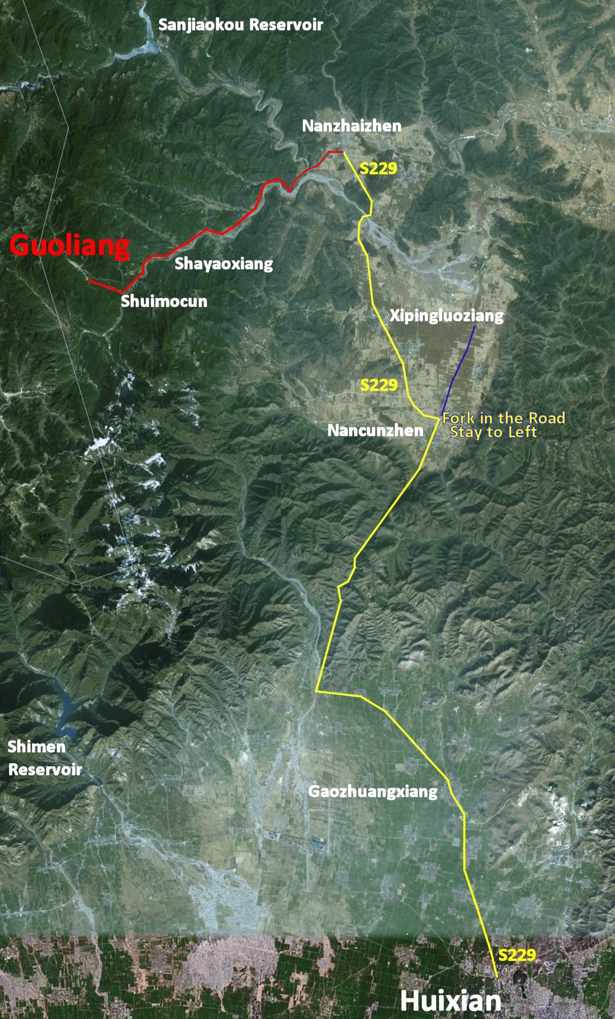
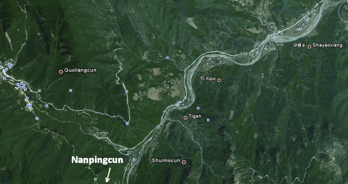
Our next
picture is a Google Earth closeup of the area around
Guoliang. As you see in the picture, the "Second
Road to Guoliang" follows the East-West River
through the valley. Please take note of
Shayaoxiang
- for some reason, this town shows up on the maps long
before Guoliang does.
|
 |
English and
Chinese Directions to Guoliang
(Courtesy of Luke from China)
郑州��万仙山
距离:约 150(160)公里
车程:约 2.5小时
线路:郑州走花园路(或走 107)
��向北直走��过黄河桥��走107郑(郑州)新(新
乡)快速道 ��新原收费站(已撤销)��过新乡��过高架桥��过十字路口(左
辉县,右濮阳) ��
下一个十字路口(左侧有一加油站)左转走新乡北环路��约走
11
公里��新辉立交右转��上新辉公路向辉县方向��抵辉县市区的第一个转盘左
转 ��辉县市
南环路��辉县市西环路��小屯转盘直走(向山西方向)��岳村收
费站(已撤销)
15
公里愚公洞��南村转盘向左转15
公里
南寨镇丁字路口左转(有
路标) ��走12
公里抵达万仙山景区
Go to Nanyang Lu or Huayuan Lu, get on G30
连霍高速east, then take
expressway (G4,
京港澳)
north towards Xinxiang. Get off on
expressway G5512
晋新 (exit after
新乡市区出口, S308) and go
west. Take 2 nd
exit (新乡西,
S229) and go north. After about 9km, follow S229 as it jogs
west with
S306 for about 4km, then continue north on
S229.
Go past
高庄乡政府, 六台山村, 五一洞, 九大洞, 石岭.
After
南村镇卫生院, follow S229 as
it forks left � this is the 3 rd
exit on the roundabout,
according to Google Maps. (Don�t take S228
straight ahead). This is about 40 km since
getting off the expressway.
Go 12 km. At the
南寨镇
intersection, turn
left off S229. After 3km (near Shanwan) there will be a
sharp bend to the right...road may now be
called
达业路. After 8.6 more km
(perhaps just after the
WanxianShan checkpoint), turn right and go
3km to the village.
~30 minutes to get on expressway going north
~50 minutes until getting off expressway at
Huixian
~1 hour on S229
13.
Turn left (i.e., off S229)
600 m
14.
Turn left
950 m
15.
Slight right
1.4 km
16.
Slight right toward
达业路
8.6 km
17.
Slight right onto
达业路
3.1 km
18.
Turn left
Destination will be on the right
250 m
|
HOW MUCH TIME?
Rick Archer's Note:
Estimates
for the trip to Guoliang range from one hour to
two and a half hours. Blog One says one
hour. Blog Two says 2 1/2 hours from
Huixian. Blog Three says 2 1/2 from
Xinxiang. A Travel Guide says 2 1/2 hours
from Huixian. When I discover the true
time, I will let you know.
Blog 1 - Used as the backdrop to
numerous Chinese films, Guoliangcun�s mountain
scenery and its delightful stone-clad village
make it an increasingly popular side-trip from
Zhengzhou. Located one
hour north of the capital city by road,
this offers a
chance to step back in time.
(Rick Archer's Note:
This claim of a one hour trip is contradicted
several times below.)
Blog 2 (Marizanne) - We
made it to Huixian. As this part of the trip was
only supposed to take maximum 2 hours, we were
already fed up at this stage. Here Marizanne
desperately had to go to the toilet and made a
dash for the public toilet. It was in a little
building far away from the main bus station
building and as soon as she entered, she knew
why.. We have seen many �strange� toilets on our
trip so far, but this was officially the worse
toilet experience of her life (bad enough to
even make it on the blog)!
The next bus journey to
our final destination, Guoliangcun, was over in
2 and a half hours
(thankfully!). We got
dropped off about 3km from the village and had
to take a taxi.
Blog 3 (Darren) -
Guoliangcun was another one of
those small towns that was incredibly difficult
to find.
By the time we
arrived at Xinxiang we
were exhausted and really didn't fancy the
prospect of getting on a taxi to get to a bus
stop to take a bus to get to another bus stop
where we could catch a bus to a town where we
could pick up a mini bus which would take us to
the bottom of a 3k hike to the place we wanted
to go. When a taxi driver offered to take us
there for about �12 we just said ok and slept in
the back of his cab for the
2 and a half hour journey.
The
only thing I really remember about that journey
was when the driver didn't fancy paying to use a
toll road he bought a packet of
cigarettes and gave it
to a farmer to let him cut across his field.
Which was pretty funny I thought.
From a
Travel Guide -
Wanxian Mountain Scenic Area, situated at the
central part of Taihang Mountains, lies 55
kilometers (34 miles) at the northwest of
Huixian City.
Officially, the entrance charge for Guo�li�ngcun
is Y35 (admission to the Wanxian Mountains
Scenic Area), although your minibus driver may
offer you a slightly better price to speed you
past the checkpoint.
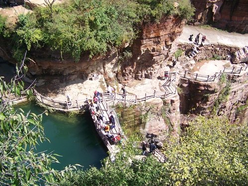
The area around guoliang has been turned into a
'geopark' with hiking trails that lead to
various geological phenomena of interest,
including caves, springs, pools, and viewing
stations.
From
another Travel Guide:
Ask the driver to drop you
at the Huixi�n stop for buses to Guoli�ngcun
(Y10, 2� hours,
depart 8am and 1pm). Note that buses from
Huixi�n may have the characters for Guoli�ng on
the window, but may (depending on passenger
number) only stop at N�np�ng, a
village at the base of the road to Guoli�ngcun.
From N�np�ng
it is a steep 3km walk to Guoli�ngcun up the
mountain road
From:
Luke from China
Sent: Monday, July 25, 2011
To: dance@ssqq.com
Subject: guoliangcun
Hi, Mr. Archer -
I live near Guoliang
and was thinking about visiting, so I used your
coordinates and Google Maps.
In answer to some of the things you were
wondering about on your page,
Google Maps says it takes about 3hrs to drive
there. From about anywhere in Zhengzhou, I think
you'd have to figure about 30 min. to get on the
freeway going north. Then, slightly under an
hour until you get off the freeway at Huixian.
Then, the total time on S229 may be about an
hour. Then, it's anybody's guess as to the last
part. I think the road is paved until you get to
the place marked Wanxian Mountain Scenic.
Oh, about the bus time ... it very well could
take a really long time on a public bus, going
from Huixian, because the buses stop EVERYWHERE.
:) And they don't go very fast.
I probably will give it a try this summer
sometime. Unfortunately I don't have a car or a
China driver's license, but a friend of ours has
a van and we may go with him. In addition to the
actual route, I'm curious to see what kind of
lodging there is in the village.
cheers, Luke
|
|
A NOTE FROM
SUHAN, THE MAN WHO GOT THE SEARCH FOR GUOLIANG STARTED
From:
Suhan
Sent: Friday, October 23, 2009 12:28 PM
To: Rick Archer
Subject: Regarding the Guoliang Tunnel
I just finished reading the story for your search. Thank
you for taking so much time to correct the information
:)
Regarding Google, it's remarkably inaccurate here
in China if you search in English.
It's much
more reliable and accurate if you search in Chinese
Characters. I have no idea why this inaccuracy occurs,
but it probably has something to do with Google's search
algorithm and the 4 tones associated with the Chinese
language. In Mandarin, He1, He2, He3, and He4 all sound
different, but people usually omit the tones and just
write He. Therefore, Henan is actually He2nan2, but it's
just marked as Henan in most US maps. There could
actually be many places names Henan but with different
tones. For example, hypothetically, there could be
He1nan1, He1nan2, etc. If you use Chinese characters,
this problem is automatically solved which results in a
much more accurate search.
I wish I had followed up with you earlier. It would have
helped you find Guoliang more easily. On the other hand,
it seems like you did get to see a lot of China through
Google Maps. There is also a Chinese website called
Baidu which provides accurate maps as well, but you'd
have to have knowledge of Mandarin to successfully
navigate the site.
Anyway, I hope this helps explain why you had such a
hard time with Google. Thank you again for your efforts.
Best of wishes.
Regards, Suhan
|
PARTING
THOUGHTS
I uncovered
some very interesting tidbits about Guoliang during my 2009
research. For example, several blogs indicated
Guoliang came to the attention of the modern world thanks to
Chinese filmmakers.
The road soon cuts directly into the side of the
vertical gorge. This feat was apparently achieved by 12
men over 6 years, before this the only access to the
plateau above was by an extremely scary path called the
Sky Stair. Owing to this, the old villages are largely
unspoiled, leading to GL becoming a very popular set for
Chinese films looking for authentic locations to use
rather than build sets of �yesteryear�. Some 80% of the
inhabitants have been used as extras at some point.
Another blog
suggested this area was used by the Chinese army in World
War II as a place to escape the Japanese invasion and
prepare for a counter-attack.
One question
that remains a mystery is Xiyagou, the parallel
universe city. Now that I have a feel for distance, I
estimate that Xiyagou is probably less than 10 miles further
south of Guoliang. What connection do these two
villages have? Why do they both have similar tunnels?
I never found an answer to this question.
Several blogs
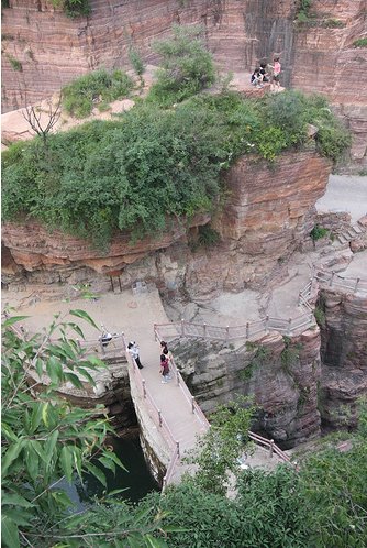
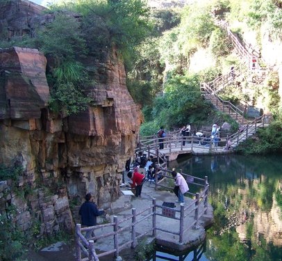
pointed out that this area has been developed as a geo-park.
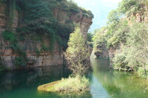
As you can see from the pictures, this area is very lovely. In addition, new hotels are springing up all over the area.
Something good is happening here. In every picture I see of Guoliang, the place appears overrun
with tourists.
|
 |
 |
Not only is the place swarming with tourists, if the rumors
can be believed, eighty percent of the residents regularly
appear in movies as well!
From a forgotten
outpost on the very edge of the world back in the 1970s,
Guoliang has obviously come a long, long way in just forty
years.
Imagine how
popular Guoliang would be if people could just find the darn
place!
If you have
read my story carefully, you have to agree the entire planet
outside of China clearly has no idea where Guoliang is
located! I still find it hard to believe
that I found a half-dozen placemarks on Google Maps and
Google Earth that are completely wrong.
I have no
explanation why there are so many mistakes. What would
cause so many people to get it wrong? I suppose people
typed in 'Guoliang' and came up with various other spots.
However, why were they so sure of themselves? Why
didn't they bother to double-check their work for accuracy?
Furthermore, why did so many people transpose Guoliang with
Xiyagou?
|
Guoliang clearly needs a better publicist.
One good web site complete with a map would do wonders for
this place!
I suppose that
until a professional comes along, I guess my web site will
have to do the trick.
You might
wonder why I dedicated several days of my life to finding
and then documenting this missing village in the middle of
nowhere. After all, I have absolutely no connection to
Guoliang whatsoever.
If you accept
the Hindu Principle of Karma, I felt I had a Karmic Debt to
this place. Thanks to my Hunan-Henan mistake back in
early 2007, I realized I was quite likely the major reason
the true location of this place has been obscured for nearly
three years.
Then when I realized that no one else on the Internet seemed
to know where this place was, I felt a compelling urge to
clear up my original mistake here. Once I have
discovered the entire planet can't seem to find the right
place, I felt it was my duty to set things right.
Besides the
mystery of Xiyagou, I guess my other confusion is to
understand why it was so hard for me to find the correct
location. I am no genius, but I am computer-literate
enough to know how to collect a vast amount of information.
Yet despite all my research, my discovery of the true
Guoliang location came down to three hours of zoom in/zoom
out hunt and peck on Google Earth. Why did it have to
be that difficult?
As you can
see, I raised many questions along the way. If anyone
of you have information to share, by all means, feel free to
comment.
Thank you very
much for reading. Maybe I will see you in Guoliang
sometime... now that everyone knows where it is!
Rick Archer
October 2009
dance@ssqq.com
|
 |
|